IMAGES TAKEN NEAR TO
Gillies Hill, STIRLING, FK7 9PG
Introduction
This page details the photographs taken nearby to Gillies Hill, FK7 9PG by members of the Geograph project.
The Geograph project started in 2005 with the aim of publishing, organising and preserving representative images for every square kilometre of Great Britain, Ireland and the Isle of Man.

There are currently over 7.5m images from over14,400 individuals and you can help contribute to the project by visiting https://www.geograph.org.uk
Image Map
Images are licensed for reuse under creativecommons.org/licenses/by-sa/2.0
Notes
- Clicking on the map will re-center to the selected point.
- The higher the marker number, the further away the image location is from the centre of the postcode.
Image Listing (13 Images Found)
Images are licensed for reuse under creativecommons.org/licenses/by-sa/2.0
Image
Details
Distance
1
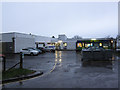
Cambusbarron Primary School
Primary school with nursery department, currently with a roll of 212 pupils aged 3 - 11.
Image: © Richard Dorrell
Taken: 13 Nov 2015
0.11 miles
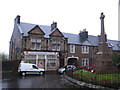
2
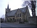
Bruce Memorial Church
Church of Scotland, Cambusbarron. http://cambusbarronchurch.org/
Image: © Callum Black
Taken: 24 Mar 2006
0.12 miles
3
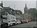
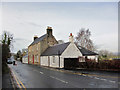
Touch Road, Cambusbarron
Bruce Memorial Church.
Image: © Alan Reid
Taken: 30 Jul 2020
0.12 miles
4
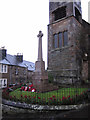
War memorial,Cambusbarron
The memorial stands below the tower of the Bruce Memorial Parish Church at the junction of Birkhill Road and St Ninian's Road.
Image: © Richard Dorrell
Taken: 13 Nov 2015
0.12 miles
5
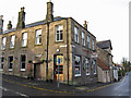
The Foresters, Cambusbarron
Public house in Main Street, Cambusbarron, on the corner of Murray Place. The hanging sign over the pavement urges passers by to 'Eat good food' and 'Drink more beer'.
Image: © Richard Dorrell
Taken: 14 Nov 2015
0.12 miles
6
Cambusbarron
Suburb of Stirling but somewhat separated from its neighbour by the M9 motorway
Image: © Richard Webb
Taken: 11 May 2008
0.12 miles
7
Post Office, Cambusbarron
The Post Office and Village Store stands at the western end of Birkhill Road, opposite the village war memorial.
See also: Image
Image: © Richard Dorrell
Taken: 13 Nov 2015
0.13 miles
8
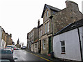
Main Street, Cambusbarron
The building with the green door is West End House - now offices. It bears the date 1879.
Image: © Richard Dorrell
Taken: 14 Nov 2015
0.13 miles
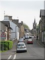
9
Main Street, Cambusbarron
Looking west, out of the village, from opposite the junction with Mill Hill.
Image: © Richard Dorrell
Taken: 14 Nov 2015
0.17 miles
10
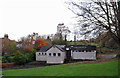
Cambusbarron Social Club
Located off The Brae, near the centre of the village.
Image: © Richard Dorrell
Taken: 14 Nov 2015
0.18 miles