IMAGES TAKEN NEAR TO
Anderson Place, STIRLING, FK7 9HR
Introduction
This page details the photographs taken nearby to Anderson Place, FK7 9HR by members of the Geograph project.
The Geograph project started in 2005 with the aim of publishing, organising and preserving representative images for every square kilometre of Great Britain, Ireland and the Isle of Man.

There are currently over 7.5m images from over14,400 individuals and you can help contribute to the project by visiting https://www.geograph.org.uk
Image Map
Images are licensed for reuse under creativecommons.org/licenses/by-sa/2.0
Notes
- Clicking on the map will re-center to the selected point.
- The higher the marker number, the further away the image location is from the centre of the postcode.
Image Listing (8 Images Found)
Images are licensed for reuse under creativecommons.org/licenses/by-sa/2.0
Image
Details
Distance
1
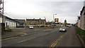
Weaver Row, St Ninians
View towards a rather busy supermarket.
Image: © Richard Webb
Taken: 14 Mar 2012
0.12 miles
4
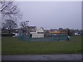
Basketball park
Dreary lunchtime at St Ninians
Image: © Callum Black
Taken: 24 Mar 2006
0.18 miles
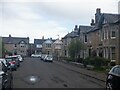
5
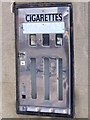
Stirling, St.Ninians
Redundant cigarette vending machine on wall of shop. 2/6d for Ten Capstan anyone?
Image: © Robert Murray
Taken: 14 May 2010
0.19 miles
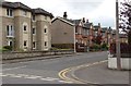
6

The High School, Stirling
No longer the High School site, they have moved nearby into a new building, but a building site.
Image: © Richard Webb
Taken: 20 Feb 2012
0.22 miles
7
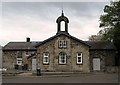
St. Ninians Parish Halls
Built 1892.
Image: © Texas Radio and The Big Beat
Taken: 4 May 2010
0.23 miles
8
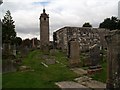
St. Ninians, Stirling
This has been an ecclesiastical site since at least the 12th century. The last church on this site was used as a gunpowder store during the final Jacobite Uprising in 1745-46 when the army of Charles Edward Stuart was besieging Stirling Castle. Either accidentally or deliberately, the gunpowder was set alight, and St Ninians Parish Kirk was completely obliterated.
Image: © Euan Nelson
Taken: 7 Sep 2014
0.24 miles