IMAGES TAKEN NEAR TO
Old Sauchie, Sauchieburn, STIRLING, FK7 9AX
Introduction
This page details the photographs taken nearby to FK7 9AX by members of the Geograph project.
The Geograph project started in 2005 with the aim of publishing, organising and preserving representative images for every square kilometre of Great Britain, Ireland and the Isle of Man.

There are currently over 7.5m images from over14,400 individuals and you can help contribute to the project by visiting https://www.geograph.org.uk
Image Map
Images are licensed for reuse under creativecommons.org/licenses/by-sa/2.0
Notes
- Clicking on the map will re-center to the selected point.
- The higher the marker number, the further away the image location is from the centre of the postcode.
Image Listing (6 Images Found)
Images are licensed for reuse under creativecommons.org/licenses/by-sa/2.0
Image
Details
Distance
1

The Great Hall at Old Sauchie
"Great Hall" is how the OS describes this fine building.
Image: © Gordon Brown
Taken: 23 Jan 2022
0.04 miles
2
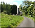
Old Sauchie
First view of Old Sauchie as you come round a bend in the track.
This is the south end view of part of a 16th century tower house, with further additions made in 17th and 18th.
Image: © Derek Ferris
Taken: 15 May 2007
0.09 miles
3
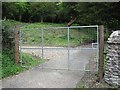
Gate, Sauchie
A new gate on the edge of the older Sauchie woodland.
Image: © Richard Webb
Taken: 15 May 2011
0.10 miles
4
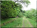
Forest road, Old Sauchie
The road descends from high on Lewis Hill. Here it is passing through an old oak wood.
Image: © Richard Webb
Taken: 15 May 2011
0.16 miles
5
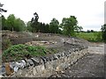
Ground works, Sauchie
Some woodland has been cleared and a new wall built.
Image: © Richard Webb
Taken: 15 May 2011
0.17 miles
