IMAGES TAKEN NEAR TO
Bellfield Road, STIRLING, FK7 8JN
Introduction
This page details the photographs taken nearby to Bellfield Road, FK7 8JN by members of the Geograph project.
The Geograph project started in 2005 with the aim of publishing, organising and preserving representative images for every square kilometre of Great Britain, Ireland and the Isle of Man.

There are currently over 7.5m images from over14,400 individuals and you can help contribute to the project by visiting https://www.geograph.org.uk
Image Map
Images are licensed for reuse under creativecommons.org/licenses/by-sa/2.0
Notes
- Clicking on the map will re-center to the selected point.
- The higher the marker number, the further away the image location is from the centre of the postcode.
Image Listing (32 Images Found)
Images are licensed for reuse under creativecommons.org/licenses/by-sa/2.0
Image
Details
Distance

2
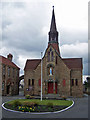
Our Lady and St Ninian's Catholic Church
Built 1927. Architect, Archibald Macpherson. Located in Quakerfield, Bannockburn.
Image: © Richard Dorrell
Taken: 3 Apr 2010
0.07 miles
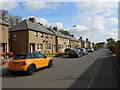
3
Newmarket, Bannockburn
View towards the police station.
Image: © Richard Webb
Taken: 19 Mar 2012
0.09 miles
4
Shops in Quakerfield, Bannockburn
These small buildings house a hair salon and a computer workshop. The spire behind is Our Lady and St Ninian's Catholic Church.
Image: © Richard Dorrell
Taken: 3 Apr 2010
0.10 miles
5
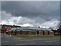
Bannockburn Library
The entrance is from Greenacre Place, though this photograph is taken from Quakerfield.
The building appears to have been designed to resemble a missile silo or bomb shelter.
No doubt, some think it is beautiful.
Image: © Richard Dorrell
Taken: 3 Apr 2010
0.12 miles


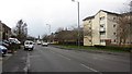
8
Lomond Drive
Lomond Drive is a short residential street consisting mainly of pebble-dashed semi detached houses. It runs from Bruce Street to Manse Drive. The back gardens of the houses on the left look out over Bannockburn Cemetery.
Image: © Nigel Mykura
Taken: 10 Sep 2015
0.13 miles
9
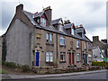
Muirhead Terrace, Newmarket, Bannockburn
A small terrace, dated 1929, standing at the south eastern end of Newmarket. The left gable end clearly shows that another building once stood against the surviving wall. The end-but-one doorway on the right is an open passage to the rear of the building.
Image: © Richard Dorrell
Taken: 3 Apr 2010
0.13 miles
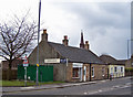
10
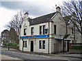
The Empire Bar, Quakerfield
One of several bars close to the centre of this small town.
Image: © Richard Dorrell
Taken: 3 Apr 2010
0.13 miles