IMAGES TAKEN NEAR TO
Munnoch Way, STIRLING, FK7 8GA
Introduction
This page details the photographs taken nearby to Munnoch Way, FK7 8GA by members of the Geograph project.
The Geograph project started in 2005 with the aim of publishing, organising and preserving representative images for every square kilometre of Great Britain, Ireland and the Isle of Man.

There are currently over 7.5m images from over14,400 individuals and you can help contribute to the project by visiting https://www.geograph.org.uk
Image Map
Images are licensed for reuse under creativecommons.org/licenses/by-sa/2.0
Notes
- Clicking on the map will re-center to the selected point.
- The higher the marker number, the further away the image location is from the centre of the postcode.
Image Listing (9 Images Found)
Images are licensed for reuse under creativecommons.org/licenses/by-sa/2.0
Image
Details
Distance
2
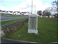
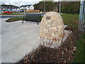
Plean colliery Memorial inscription stone
Image: © James McPherson
Taken: 16 Apr 2008
0.14 miles
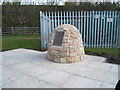
4
Plean disaster memorial cairn and gardens
Image: © James McPherson
Taken: 16 Apr 2008
0.15 miles
5
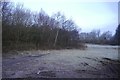
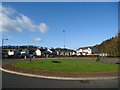
Informal open space, Plean
Has the appearance of former colliery land.
Image: © Richard Webb
Taken: 3 Mar 2017
0.17 miles
6
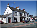
The Plean Tavern, Stirlingshire
This popular Tavern sits on the Main Street of this former Mining Town which lies right next to the M9 Motorway.
Image: © Kevin Rae
Taken: 29 Apr 2006
0.18 miles
7

Shops, Plean
A row of shops from a corner shop to the post office.
Image: © Richard Webb
Taken: 3 Jun 2010
0.19 miles
8
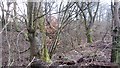
Plean Colliery mineral line
A railway cutting, now a woodland at the back of Plean.
Image: © Richard Webb
Taken: 1 Mar 2012
0.22 miles