IMAGES TAKEN NEAR TO
Whins Of Milton, STIRLING, FK7 8EP
Introduction
This page details the photographs taken nearby to FK7 8EP by members of the Geograph project.
The Geograph project started in 2005 with the aim of publishing, organising and preserving representative images for every square kilometre of Great Britain, Ireland and the Isle of Man.

There are currently over 7.5m images from over14,400 individuals and you can help contribute to the project by visiting https://www.geograph.org.uk
Image Map
Images are licensed for reuse under creativecommons.org/licenses/by-sa/2.0
Notes
- Clicking on the map will re-center to the selected point.
- The higher the marker number, the further away the image location is from the centre of the postcode.
Image Listing (15 Images Found)
Images are licensed for reuse under creativecommons.org/licenses/by-sa/2.0
Image
Details
Distance
1
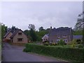
Stirling, Milton village
A view of Millside.
The road leads down to the Bannock where stood Beaton's Mill, allegedly the place where King James III was murdered soon after the Battle of Sauchieburn on 11th. June, 1588.
Image: © Robert Murray
Taken: 1 Jun 2011
0.04 miles
2
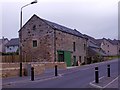
Stirling, Milton village
Milton Corn Mill which has been converted into a dwelling. The lade which at this juncture has been culverted flows under the lower buildings and across the road from L to R.
Image: © Robert Murray
Taken: 1 Jun 2011
0.07 miles
3

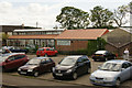
Land Rover dealership
This is Pentland Land Rover in Whins of Milton.
The nearest vehicle, side-on to the camera, is the recently announced 'new' Defender. As this particular example was quite mud-splattered, I believe it is the dealership demonstrator.
Image: © Richard Dorrell
Taken: 26 Sep 2020
0.08 miles
4
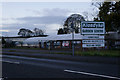
Pentland Jaguar, Stirling
Located in Glasgow Road, Whins of Milton.
Image: © Richard Dorrell
Taken: 26 Sep 2020
0.08 miles
5

Pentland Land Rover
This is the Stirling branch, located in Glasgow Road, Whins of Milton.
Image: © Richard Dorrell
Taken: 26 Sep 2020
0.08 miles
6
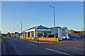
The Conservatory Centre and Topiary Coffee Shop, Glasgow Road, Stirling
Image: © Mike Pennington
Taken: 30 May 2011
0.13 miles
7
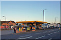
Petrol station, Glasgow Road
Open but deserted - about 5.00pm, Saturday afternoon.
Image: © Richard Dorrell
Taken: 26 Sep 2020
0.14 miles
9
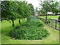
Stirling, Milton
The mill lade which is abstracted from the Bannock Burn at the 'Iron Falls' at Chartershall. This lade was the main feeder for the Milton corn mill and woollen mills at the western end of the Dryfield gorge on the Bannock where a considerable fall of water was achieved.
The next square seems to run across the photo at the first tree on the left .....
Image: © Robert Murray
Taken: 1 Jun 2011
0.18 miles
10
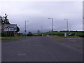
Stirling, Pirnhall
New(ish) roundabout at Pirnhall Business Park south of Milton.
Image: © Robert Murray
Taken: 1 Jun 2011
0.18 miles