IMAGES TAKEN NEAR TO
Bannockburn, STIRLING, FK7 8AQ
Introduction
This page details the photographs taken nearby to FK7 8AQ by members of the Geograph project.
The Geograph project started in 2005 with the aim of publishing, organising and preserving representative images for every square kilometre of Great Britain, Ireland and the Isle of Man.

There are currently over 7.5m images from over14,400 individuals and you can help contribute to the project by visiting https://www.geograph.org.uk
Image Map
Images are licensed for reuse under creativecommons.org/licenses/by-sa/2.0
Notes
- Clicking on the map will re-center to the selected point.
- The higher the marker number, the further away the image location is from the centre of the postcode.
Image Listing (3 Images Found)
Images are licensed for reuse under creativecommons.org/licenses/by-sa/2.0
Image
Details
Distance
1
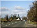
Stirling, the A9
The old main route from Edinburgh to Inverness. Bannockburn Hospital is screened by the trees on left.
Image: © Robert Murray
Taken: 24 Feb 2012
0.14 miles

3
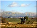
Stirling, Gartclush
View north across rolling farmland towards the Ochils.
Image: © Robert Murray
Taken: 24 Feb 2012
0.20 miles