
IMAGES TAKEN NEAR TO
Mace Court, STIRLING, FK7 7XA
Introduction
This page details the photographs taken nearby to Mace Court, FK7 7XA by members of the Geograph project.
The Geograph project started in 2005 with the aim of publishing, organising and preserving representative images for every square kilometre of Great Britain, Ireland and the Isle of Man.

There are currently over 7.5m images from over14,400 individuals and you can help contribute to the project by visiting https://www.geograph.org.uk
Image Map
Images are licensed for reuse under creativecommons.org/licenses/by-sa/2.0
Notes
- Clicking on the map will re-center to the selected point.
- The higher the marker number, the further away the image location is from the centre of the postcode.
Image Listing (7 Images Found)
Images are licensed for reuse under creativecommons.org/licenses/by-sa/2.0
Image
Details
Distance
1
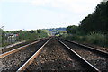
Off the rails
This is the main railway line from Falkirk (Edinburgh and Glasgow) to Stirling, which is behind me as I took this photo.
Image: © Steven Hill
Taken: 23 Sep 2006
0.09 miles
2

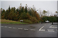
Woodland, Pike Road
A young woodland between a road and the railway. It dates from the development of the land for housing.
Image: © Richard Webb
Taken: 18 Jan 2013
0.10 miles

6
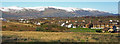
St Ninians to the Ochil Hills
The Ochils from near the junction of Broom Rd and Bannockburn Rd.
Image: © Robert Ferguson
Taken: 11 Feb 2009
0.21 miles
7
Bannockburn, Balquhidderock Wood
The area in and just beyond these woods is one of two main candidate sites for the great battle in 1314.
Image: © Robert Murray
Taken: 28 May 2011
0.22 miles