IMAGES TAKEN NEAR TO
Meadowforth Road, STIRLING, FK7 7SA
Introduction
This page details the photographs taken nearby to Meadowforth Road, FK7 7SA by members of the Geograph project.
The Geograph project started in 2005 with the aim of publishing, organising and preserving representative images for every square kilometre of Great Britain, Ireland and the Isle of Man.

There are currently over 7.5m images from over14,400 individuals and you can help contribute to the project by visiting https://www.geograph.org.uk
Image Map
Images are licensed for reuse under creativecommons.org/licenses/by-sa/2.0
Notes
- Clicking on the map will re-center to the selected point.
- The higher the marker number, the further away the image location is from the centre of the postcode.
Image Listing (21 Images Found)
Images are licensed for reuse under creativecommons.org/licenses/by-sa/2.0
Image
Details
Distance
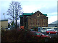
1
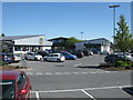
Small Shopping Area beside the A905, Stirling
South-east of Stirling city centre.
Image: © G Laird
Taken: 6 May 2017
0.01 miles
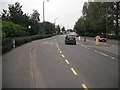
2
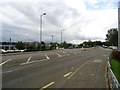
Stirling, Kerse Road roundabout
View to the city.
Image: © Robert Murray
Taken: 13 Aug 2011
0.07 miles
3
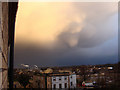
Beginning of Funnel Cloud Over Stirling
Photo taken out my kitchen window at the strange cloud formation over the valley.
Image: © Robyn Stewart
Taken: 26 Jan 2011
0.07 miles
4

Beginning of Funnel Cloud Over Stirling
Close up of strange cloud formation over Stirling.
Image: © Robyn Stewart
Taken: 26 Jan 2011
0.08 miles
5
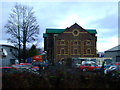
Old industrial building
What appears to be an old warehouse amongst the new car dealerships alongside the railway line to the south of Stirling station.
Image: © Thomas Nugent
Taken: 2 Jan 2013
0.08 miles
6
Old industrial building
What appears to be an old warehouse amongst the new car dealerships alongside the railway line to the south of Stirling station.
Image: © Thomas Nugent
Taken: 2 Jan 2013
0.08 miles

8
Kerse Road
The A905 running through a largely industrial area to the east of the centre of Stirling.
Image: © Richard Webb
Taken: 18 Sep 2009
0.11 miles
9
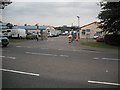
Springkerse Complex
Council depot off Kerse Road.
Image: © Richard Webb
Taken: 18 Sep 2009
0.14 miles
10
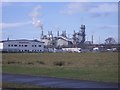
Factory
Open land, probably under threat of development at the south side of Stirling's industrial estate.
Image: © Callum Black
Taken: 3 Mar 2006
0.14 miles