IMAGES TAKEN NEAR TO
Broadleys Industrial Park, Kerse Road, STIRLING, FK7 7RX
Introduction
This page details the photographs taken nearby to Broadleys Industrial Park, Kerse Road, FK7 7RX by members of the Geograph project.
The Geograph project started in 2005 with the aim of publishing, organising and preserving representative images for every square kilometre of Great Britain, Ireland and the Isle of Man.

There are currently over 7.5m images from over14,400 individuals and you can help contribute to the project by visiting https://www.geograph.org.uk
Image Map
Images are licensed for reuse under creativecommons.org/licenses/by-sa/2.0
Notes
- Clicking on the map will re-center to the selected point.
- The higher the marker number, the further away the image location is from the centre of the postcode.
Image Listing (6 Images Found)
Images are licensed for reuse under creativecommons.org/licenses/by-sa/2.0
Image
Details
Distance
1
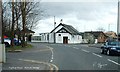
The Halfway House
The name has created arguments for years whenever the question arrises "halfway between where ???"
Image: © Robert Ferguson
Taken: 15 Mar 2009
0.17 miles
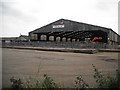
3
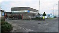
Springkerse Industrial Estate
Munro Road.
Image: © Richard Webb
Taken: 17 Jan 2013
0.22 miles

5
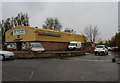
Springkerse Retail Park
Typical retail park on Stirling's eastern edge. The map today is unrecognisable compared to the 1940's map.
Image: © Callum Black
Taken: 3 Mar 2006
0.24 miles
6
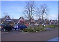
Caledonian Marts
One of two livestock markets in Stirling.
Image: © Richard Webb
Taken: 18 Sep 2009
0.24 miles