IMAGES TAKEN NEAR TO
Bannockburn, STIRLING, FK7 7BB
Introduction
This page details the photographs taken nearby to FK7 7BB by members of the Geograph project.
The Geograph project started in 2005 with the aim of publishing, organising and preserving representative images for every square kilometre of Great Britain, Ireland and the Isle of Man.

There are currently over 7.5m images from over14,400 individuals and you can help contribute to the project by visiting https://www.geograph.org.uk
Image Map
Images are licensed for reuse under creativecommons.org/licenses/by-sa/2.0
Notes
- Clicking on the map will re-center to the selected point.
- The higher the marker number, the further away the image location is from the centre of the postcode.
Image Listing (5 Images Found)
Images are licensed for reuse under creativecommons.org/licenses/by-sa/2.0
Image
Details
Distance
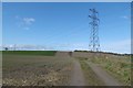
1
A narrow field
Stubble in a field squeezed between a railway cutting and the B9124.
Image: © Richard Webb
Taken: 18 Oct 2010
0.07 miles
3
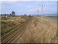
Railway line
This is the line to Stirling and beyond. The picture was taken from a bridge on the B9124,part of which can be seen in the top left of the picture. The view is towards Stirling.
Image: © Paul McIlroy
Taken: 24 Mar 2007
0.18 miles
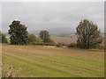
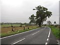
4
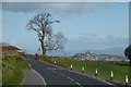
B9124, Easter Greenyards
View towards Stirling Castle.
Image: © Richard Webb
Taken: 25 Apr 2017
0.20 miles