IMAGES TAKEN NEAR TO
Easterton Grove, STIRLING, FK7 7AQ
Introduction
This page details the photographs taken nearby to Easterton Grove, FK7 7AQ by members of the Geograph project.
The Geograph project started in 2005 with the aim of publishing, organising and preserving representative images for every square kilometre of Great Britain, Ireland and the Isle of Man.

There are currently over 7.5m images from over14,400 individuals and you can help contribute to the project by visiting https://www.geograph.org.uk
Image Map
Images are licensed for reuse under creativecommons.org/licenses/by-sa/2.0
Notes
- Clicking on the map will re-center to the selected point.
- The higher the marker number, the further away the image location is from the centre of the postcode.
Image Listing (8 Images Found)
Images are licensed for reuse under creativecommons.org/licenses/by-sa/2.0
Image
Details
Distance
1
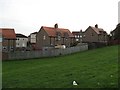
Cowie
Taken from Mount Oliphant, houses in the former mining village of Cowie.
Image: © Richard Webb
Taken: 4 Nov 2006
0.08 miles
3
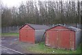
Garages, Cowie
On Ochilview but in this case the view is of Norbord's perimeter fence.
Image: © Richard Webb
Taken: 22 Feb 2017
0.12 miles
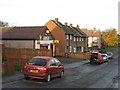
5
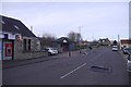
Main Street, Cowie
By the post office.
Image: © Richard Webb
Taken: 22 Feb 2017
0.22 miles
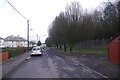
6
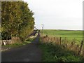
To Scotstoun Road
Rough road just outside Cowie.
Image: © Richard Webb
Taken: 4 Nov 2006
0.23 miles
7
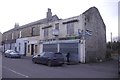
Ruined shop, Cowie
Main Street, Cowie.
Image: © Richard Webb
Taken: 22 Feb 2017
0.24 miles
8
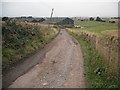
Cowiehall
The Hillhead to Cowie road descends to Cowie past Cowiehall. The road is used by route 76 of the National Cycle Network.
Image: © Richard Webb
Taken: 18 Sep 2009
0.24 miles