IMAGES TAKEN NEAR TO
Park Crescent, STIRLING, FK7 0EL
Introduction
This page details the photographs taken nearby to Park Crescent, FK7 0EL by members of the Geograph project.
The Geograph project started in 2005 with the aim of publishing, organising and preserving representative images for every square kilometre of Great Britain, Ireland and the Isle of Man.

There are currently over 7.5m images from over14,400 individuals and you can help contribute to the project by visiting https://www.geograph.org.uk
Image Map
Images are licensed for reuse under creativecommons.org/licenses/by-sa/2.0
Notes
- Clicking on the map will re-center to the selected point.
- The higher the marker number, the further away the image location is from the centre of the postcode.
Image Listing (16 Images Found)
Images are licensed for reuse under creativecommons.org/licenses/by-sa/2.0
Image
Details
Distance
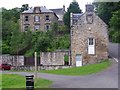
1
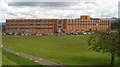
Bannockburn High School
Viewed from the south. (Stirling lies off the picture to the left.)
Image: © Duncan
Taken: 12 Jun 2006
0.09 miles
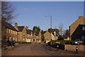
2
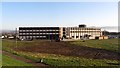
Bannockburn High School
A new building as is usual in Stirling.
Image: © Richard Webb
Taken: 27 Mar 2012
0.10 miles
3
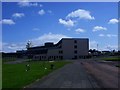
Bannockburn high School
See Image for another view.
Image: © Robert Murray
Taken: 28 May 2011
0.10 miles
4
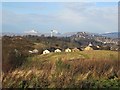
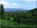
Stirling seen from Bannockburn
View towards the castle, Ben Vorlich and Stùc a' Chroin seen from the grounds of Bannockburn High School.
Image: © Richard Webb
Taken: 30 Nov 2012
0.16 miles
5
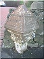
Old Milepost by the A9, Bannockburn Road, Bannockburn
Stirling BB casting by the A9, in parish of St Ninians (Stirling District), Bannockburn, near bus stop, nearly opposite school, Southwest side of road.
Inscription reads:-
: STIRLING / 2 / MILES : : FALKIRK / 9m / EDINBURGH / 38½m(?) :
Surveyed
Milestone Society National ID: ST_STFK02
Image: © Milestone Society
Taken: Unknown
0.18 miles
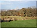
6
Bannockburn
The steep sided gorge called the Dryfield that the Bannock flows through from Milton ends beyond the trees and the river enters the flat lands of the carse on its way to the Forth.
Image: © Robert Murray
Taken: 28 May 2011
0.18 miles
7
Bannockburn, the Path
The building (now a house) on the right was almost certainly part of a carpet factory called the Skeoch Mill on this site and depicted on the First Edition of the O.S. map [Stirling Sheet XVII.12 St. Ninians] surveyed in 1860.
Image: © Robert Murray
Taken: 28 May 2011
0.20 miles
8
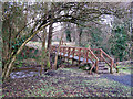
Footbridge over Bannock Burn
The bridge is in a path from Old Town to Ladeside.
Image: © Richard Dorrell
Taken: 3 Apr 2010
0.21 miles
10
Balquhidderock Wood
An oakwood near to Bannockburn High School.
Image: © Richard Webb
Taken: 30 Nov 2012
0.21 miles