IMAGES TAKEN NEAR TO
Robertson Place, STIRLING, FK7 0DL
Introduction
This page details the photographs taken nearby to Robertson Place, FK7 0DL by members of the Geograph project.
The Geograph project started in 2005 with the aim of publishing, organising and preserving representative images for every square kilometre of Great Britain, Ireland and the Isle of Man.

There are currently over 7.5m images from over14,400 individuals and you can help contribute to the project by visiting https://www.geograph.org.uk
Image Map
Images are licensed for reuse under creativecommons.org/licenses/by-sa/2.0
Notes
- Clicking on the map will re-center to the selected point.
- The higher the marker number, the further away the image location is from the centre of the postcode.
Image Listing (13 Images Found)
Images are licensed for reuse under creativecommons.org/licenses/by-sa/2.0
Image
Details
Distance
1
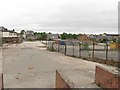
Former industrial site, Maitland Crescent
Tidy but empty looking locked area in St Ninians.
Image: © Richard Webb
Taken: 15 May 2011
0.05 miles
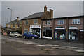
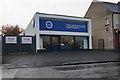
3

Your Spiced
Carry out food shop and pharmacy on Bannockburn Road.
Image: © Richard Webb
Taken: 18 Jan 2013
0.09 miles
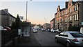
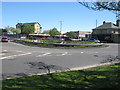
6
Road junction at St. Ninian's, Stirling
Image: © Alpin Stewart
Taken: 1 Oct 2021
0.13 miles
7
Thirty Degrees Laundry, Barndale Road, Stirling
Image: © Ian S
Taken: 23 Oct 2014
0.14 miles
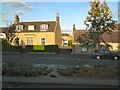
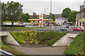
8
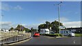
Roundabout at St Ninians
In the early 1960s, this junction was very different. There was no exit to the north and there were no M80 and M9 motorways. All traffic therefore had to go through Stirling. This was then the intersection of the A80 from Glasgow and the A9 from Edinburgh. It was then a notorious bottleneck.
Image: © G Laird
Taken: 6 May 2017
0.15 miles
10
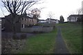
Path, Broomridge
Looking up towards the A9.
Image: © Richard Webb
Taken: 2 Feb 2018
0.17 miles