IMAGES TAKEN NEAR TO
Shirras Brae Road, STIRLING, FK7 0BA
Introduction
This page details the photographs taken nearby to Shirras Brae Road, FK7 0BA by members of the Geograph project.
The Geograph project started in 2005 with the aim of publishing, organising and preserving representative images for every square kilometre of Great Britain, Ireland and the Isle of Man.

There are currently over 7.5m images from over14,400 individuals and you can help contribute to the project by visiting https://www.geograph.org.uk
Image Map
Images are licensed for reuse under creativecommons.org/licenses/by-sa/2.0
Notes
- Clicking on the map will re-center to the selected point.
- The higher the marker number, the further away the image location is from the centre of the postcode.
Image Listing (8 Images Found)
Images are licensed for reuse under creativecommons.org/licenses/by-sa/2.0
Image
Details
Distance
1
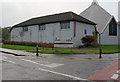
North Parish Church on Springfield Road, Braehead
Image: © Ian S
Taken: 23 Oct 2014
0.17 miles
2
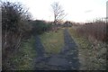
Path junction, Broomridge
Once a sandy, broom covered ridge above Broomridge Farm, it was not built upon and remains a broomy rig to this day.
As a visitor, can I say the cleanliness of the area is a credit to those who live there.
Image: © Richard Webb
Taken: 2 Feb 2018
0.18 miles
3
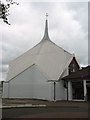
The North Church
North Parish Church, Stirling.
Image: © Steven Hill
Taken: 11 Jul 2004
0.18 miles
4
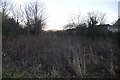
A wild patch, Broomridge
Next to a mown games field.
Image: © Richard Webb
Taken: 2 Feb 2018
0.20 miles
5
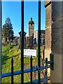
St Ninian's Old Parish Church belfry and churchyard, Stirling
The churchyard seems to be kept locked now. An event in 2018 was described as "a rare chance to explore" it.
Image: © Claire Pegrum
Taken: 18 Feb 2020
0.22 miles
6
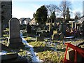
St Ninians Old Parish Graveyard
A depressing sight seeing this historic graveyard in such a sorry and neglected state.
Image: © Robert Ferguson
Taken: Unknown
0.23 miles
7
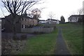
Path, Broomridge
Looking up towards the A9.
Image: © Richard Webb
Taken: 2 Feb 2018
0.23 miles
8
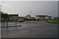
Houses on Carrick Court off Broom Road, Braehead
Image: © Ian S
Taken: 23 Oct 2014
0.24 miles