IMAGES TAKEN NEAR TO
Stirling Road, DENNY, FK6 6RF
Introduction
This page details the photographs taken nearby to Stirling Road, FK6 6RF by members of the Geograph project.
The Geograph project started in 2005 with the aim of publishing, organising and preserving representative images for every square kilometre of Great Britain, Ireland and the Isle of Man.

There are currently over 7.5m images from over14,400 individuals and you can help contribute to the project by visiting https://www.geograph.org.uk
Image Map
Images are licensed for reuse under creativecommons.org/licenses/by-sa/2.0
Notes
- Clicking on the map will re-center to the selected point.
- The higher the marker number, the further away the image location is from the centre of the postcode.
Image Listing (10 Images Found)
Images are licensed for reuse under creativecommons.org/licenses/by-sa/2.0
Image
Details
Distance
1
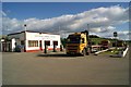
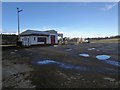
Easterton Service Station
An oldie-worldy type service station.
I'm sure those museum-piece petrol pumps don't actually work though.
Image: © Texas Radio and The Big Beat
Taken: 29 Aug 2010
0.02 miles
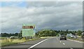
3
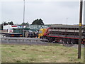
Truckers stop off A872
Farmland surrounds the cafe
Image: © Angela Mudge
Taken: 20 Jul 2006
0.06 miles
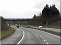
6
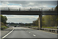
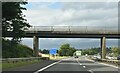
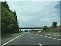
Stirling : The M80
Looking along the M80 Motorway.
Image: © Lewis Clarke
Taken: 25 Apr 2016
0.16 miles
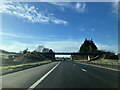
7
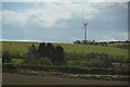
Stirling : Countryside Scenery
Looking across the grassy fields and countryside with a wind turbine in view.
Image: © Lewis Clarke
Taken: 25 Apr 2016
0.16 miles