IMAGES TAKEN NEAR TO
DENNY, FK6 5HH
Introduction
This page details the photographs taken nearby to FK6 5HH by members of the Geograph project.
The Geograph project started in 2005 with the aim of publishing, organising and preserving representative images for every square kilometre of Great Britain, Ireland and the Isle of Man.

There are currently over 7.5m images from over14,400 individuals and you can help contribute to the project by visiting https://www.geograph.org.uk
Image Map
Images are licensed for reuse under creativecommons.org/licenses/by-sa/2.0
Notes
- Clicking on the map will re-center to the selected point.
- The higher the marker number, the further away the image location is from the centre of the postcode.
Image Listing (1 Images Found)
Images are licensed for reuse under creativecommons.org/licenses/by-sa/2.0
Image
Details
Distance
1
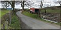
The start of a right of way
The sign reads:
"Public footpath to Fankerton / Stoneywood"
See http://www.geograph.org.uk/photo/1831316 for the opposite end of this route.
Image: © Lairich Rig
Taken: 19 Apr 2010
0.18 miles