IMAGES TAKEN NEAR TO
Randolph Gardens, DENNY, FK6 5DB
Introduction
This page details the photographs taken nearby to Randolph Gardens, FK6 5DB by members of the Geograph project.
The Geograph project started in 2005 with the aim of publishing, organising and preserving representative images for every square kilometre of Great Britain, Ireland and the Isle of Man.

There are currently over 7.5m images from over14,400 individuals and you can help contribute to the project by visiting https://www.geograph.org.uk
Image Map (Loading...)


Getting Data...Please wait
Leaflet Map data © OpenStreetMap
Images are licensed for reuse under creativecommons.org/licenses/by-sa/2.0
Notes
- Clicking on the map will re-center to the selected point.
- The higher the marker number, the further away the image location is from the centre of the postcode.
Image Listing (7 Images Found)
Images are licensed for reuse under creativecommons.org/licenses/by-sa/2.0
Image
Details
Distance
1
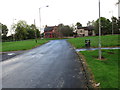
Castlerankine Road joining Nethermains Road (A872) in Denny
Looking eastward.
Image: © Peter Wood
Taken: 1 Oct 2017
0.15 miles
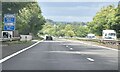
4
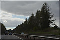
Falkirk : The M80 Motorway
Looking along the M80 Motorway.
Image: © Lewis Clarke
Taken: 25 Apr 2016
0.17 miles
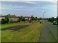
5
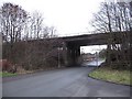
Under the M80, Denny
A minor road running beneath the motorway into Denny.
Image: © Richard Webb
Taken: 17 Jan 2009
0.22 miles
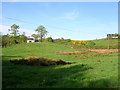
6
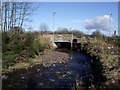
Denny, Fintry Road bridge.
The Castlerankine Burn flows through in spate towards the Carron.
Image: © Robert Murray
Taken: 10 Feb 2011
0.23 miles