IMAGES TAKEN NEAR TO
Ferguson Drive, DENNY, FK6 5AF
Introduction
This page details the photographs taken nearby to Ferguson Drive, FK6 5AF by members of the Geograph project.
The Geograph project started in 2005 with the aim of publishing, organising and preserving representative images for every square kilometre of Great Britain, Ireland and the Isle of Man.

There are currently over 7.5m images from over14,400 individuals and you can help contribute to the project by visiting https://www.geograph.org.uk
Image Map
Images are licensed for reuse under creativecommons.org/licenses/by-sa/2.0
Notes
- Clicking on the map will re-center to the selected point.
- The higher the marker number, the further away the image location is from the centre of the postcode.
Image Listing (5 Images Found)
Images are licensed for reuse under creativecommons.org/licenses/by-sa/2.0
Image
Details
Distance
4
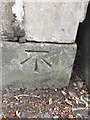
OS Cut Mark: Wall Junction #27/29 Glasgow Road, Denny
Ordnance Survey Cut Mark: Wall Junction #27/29 Glasgow Road, Denny
Image: © thejackrustles
Taken: 8 Sep 2019
0.24 miles
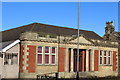
5
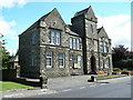
Denny Town House
Frequently known elsewhere as 'town halls'.
Image: © James Allan
Taken: 13 Jul 2006
0.25 miles