IMAGES TAKEN NEAR TO
Quintinshill Drive, LARBERT, FK5 4XU
Introduction
This page details the photographs taken nearby to Quintinshill Drive, FK5 4XU by members of the Geograph project.
The Geograph project started in 2005 with the aim of publishing, organising and preserving representative images for every square kilometre of Great Britain, Ireland and the Isle of Man.

There are currently over 7.5m images from over14,400 individuals and you can help contribute to the project by visiting https://www.geograph.org.uk
Image Map
Images are licensed for reuse under creativecommons.org/licenses/by-sa/2.0
Notes
- Clicking on the map will re-center to the selected point.
- The higher the marker number, the further away the image location is from the centre of the postcode.
Image Listing (25 Images Found)
Images are licensed for reuse under creativecommons.org/licenses/by-sa/2.0
Image
Details
Distance
1
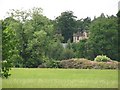
Larbert House
A glimpse of the ruins of Larbert House from the A9.
Image: © Richard Webb
Taken: 23 Jun 2010
0.02 miles
2
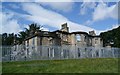
Larbert House (ruin)
Larbert House, now unroofed, is situated to the W of an ornamental loch to the W of Larbert. The house now lies to the SSE of the recently completed new Royal Scottish National Hospital (NS88SE 271).
The main (middle) section was completed about 1820, but the subsequent Victorian additions which include an ornate conservatory and Porte cochere with
doric columns. The building was latterly utilised as staff accommodation by the adjacent mental hospital. The house is depicted as roofed on the 1st Edition of the OS 6-inch (and 25-inch) map (Stirlingshire, 1865, sheet xxiv) and on all the subsequent historical editions of the OS maps. The current OS digital maps show the house as being roofed, but a fire about five years ago has led to its removal. (RCAHMS)
Image: © Texas Radio and The Big Beat
Taken: 12 Sep 2010
0.02 miles
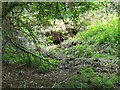
3
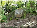
Larbert Estate, ice house
Long since bricked up.
Image: © Robert Murray
Taken: 22 Apr 2011
0.05 miles
4
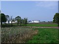
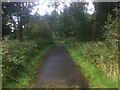
Larbert House Policies
Looking along the bank of the lake towards the new Forth Valley Royal Hospital.
Image: © Robert Murray
Taken: 22 Apr 2011
0.09 miles
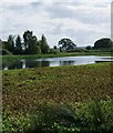
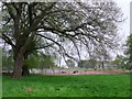
5

Larbert House lake
The island on the left with a glimpse of the old mansion house on the hill. The shallow lake has perch and pike. Much of it is covered by plant life.
Image: © Robert Murray
Taken: 22 Apr 2011
0.09 miles
7
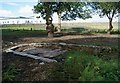
Larbert House Ornamental Loch "Dock"
"Dock" is possibly and probably not the correct word.
It's basically where the people would get in and out of the boats
and where the boats would be tied. The level of the loch has obviously
dropped considerably as this structure is now many yards from the water.
Image: © Texas Radio and The Big Beat
Taken: 12 Sep 2010
0.11 miles
8
Larbert House - Ornamental Loch
Image: © Texas Radio and The Big Beat
Taken: 12 Sep 2010
0.11 miles
9
Larbert House Policies
A glade sheltering the entrance to an old tunnel recently re-discovered after the clearing of the rhododendron. The tunnel (if it is that) is aligned in the direction of the old stables courtyard approx. 100m WSW.
See BBC news report > http://www.bbc.co.uk/news/uk-scotland-tayside-central-12717639
Image: © Robert Murray
Taken: 22 Apr 2011
0.11 miles
10
Larbert Policies
Grazing for prize herd with the ornamental lake in the background.
Image: © Robert Murray
Taken: 22 Apr 2011
0.12 miles