IMAGES TAKEN NEAR TO
Falcon Drive, LARBERT, FK5 4QX
Introduction
This page details the photographs taken nearby to Falcon Drive, FK5 4QX by members of the Geograph project.
The Geograph project started in 2005 with the aim of publishing, organising and preserving representative images for every square kilometre of Great Britain, Ireland and the Isle of Man.

There are currently over 7.5m images from over14,400 individuals and you can help contribute to the project by visiting https://www.geograph.org.uk
Image Map
Images are licensed for reuse under creativecommons.org/licenses/by-sa/2.0
Notes
- Clicking on the map will re-center to the selected point.
- The higher the marker number, the further away the image location is from the centre of the postcode.
Image Listing (6 Images Found)
Images are licensed for reuse under creativecommons.org/licenses/by-sa/2.0
Image
Details
Distance
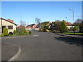
2
Heading to Larbert
In the former county of Stirlingshire.
Image: © James Denham
Taken: 18 Apr 2009
0.21 miles
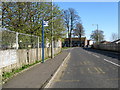
3
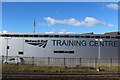
Network Rail Training Centre, Larbert
Located close to Larbert station.
Image: © Richard Dorrell
Taken: 19 Oct 2021
0.22 miles
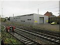
5
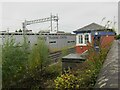
Signal box and Training Centre
Viewed over a wall alongside Muirhall Road, the signal box is Larbert North, and has been disused since 2017. The Larbert Network Rail Training Centre stands on the opposite side of the railway.
Image: © Richard Dorrell
Taken: 19 Oct 2021
0.25 miles
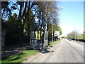
6
Network Rail Training Centre, Larbert
Image: © Leslie Barrie
Taken: 10 Oct 2013
0.25 miles