IMAGES TAKEN NEAR TO
Burns Avenue, LARBERT, FK5 4FB
Introduction
This page details the photographs taken nearby to Burns Avenue, FK5 4FB by members of the Geograph project.
The Geograph project started in 2005 with the aim of publishing, organising and preserving representative images for every square kilometre of Great Britain, Ireland and the Isle of Man.

There are currently over 7.5m images from over14,400 individuals and you can help contribute to the project by visiting https://www.geograph.org.uk
Image Map
Images are licensed for reuse under creativecommons.org/licenses/by-sa/2.0
Notes
- Clicking on the map will re-center to the selected point.
- The higher the marker number, the further away the image location is from the centre of the postcode.
Image Listing (5 Images Found)
Images are licensed for reuse under creativecommons.org/licenses/by-sa/2.0
Image
Details
Distance
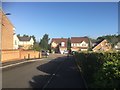
3
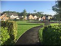
Housing
New houses at The Inches Larbert seen from west of the railway line to Stirling.
Image: © Paul McIlroy
Taken: 27 Dec 2006
0.11 miles
4
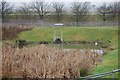
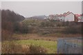
Drainage pond
All new build housing schemes are obliged by the regulations to provide drainage ponds to filter rain and other surface water, this one is at The Inches Housing Estate. The M876 motorway can be seen across the top of the picture.
Image: © Paul McIlroy
Taken: 27 Dec 2006
0.11 miles
5
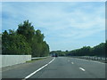
M876 crossing railway bridge near Shiels Farm
Image: © Colin Pyle
Taken: 11 Jun 2015
0.15 miles