IMAGES TAKEN NEAR TO
Arthurs Drive, LARBERT, FK5 4DP
Introduction
This page details the photographs taken nearby to Arthurs Drive, FK5 4DP by members of the Geograph project.
The Geograph project started in 2005 with the aim of publishing, organising and preserving representative images for every square kilometre of Great Britain, Ireland and the Isle of Man.

There are currently over 7.5m images from over14,400 individuals and you can help contribute to the project by visiting https://www.geograph.org.uk
Image Map
Images are licensed for reuse under creativecommons.org/licenses/by-sa/2.0
Notes
- Clicking on the map will re-center to the selected point.
- The higher the marker number, the further away the image location is from the centre of the postcode.
Image Listing (9 Images Found)
Images are licensed for reuse under creativecommons.org/licenses/by-sa/2.0
Image
Details
Distance
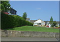
1
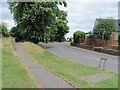
Lodge Drive
Residential street off Stenhouse Road.
Image: © Richard Webb
Taken: 23 Jun 2010
0.05 miles
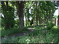
2
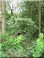
Woodland, Carron Dams
An area of woodland seen from Stenhouse Road.
Image: © Richard Webb
Taken: 23 Jun 2010
0.09 miles
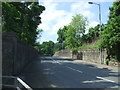
3
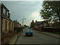
Church Street, Stenhousemuir
Through traffic has been excluded from this road, which runs out from the centre of Stenhousemuir
Image: © Oliver Dixon
Taken: 10 May 2004
0.15 miles
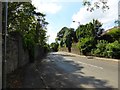
4
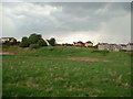
Housing overlooking open land adjacent to New Carron Road, Stenhousemuir
Image: © Oliver Dixon
Taken: 10 May 2004
0.19 miles
9
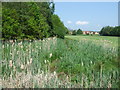
Small wetland and woodland off Stenhouse Road
Image: © JThomas
Taken: 25 May 2017
0.24 miles