IMAGES TAKEN NEAR TO
Carronvale Avenue, LARBERT, FK5 3LL
Introduction
This page details the photographs taken nearby to Carronvale Avenue, FK5 3LL by members of the Geograph project.
The Geograph project started in 2005 with the aim of publishing, organising and preserving representative images for every square kilometre of Great Britain, Ireland and the Isle of Man.

There are currently over 7.5m images from over14,400 individuals and you can help contribute to the project by visiting https://www.geograph.org.uk
Image Map
Images are licensed for reuse under creativecommons.org/licenses/by-sa/2.0
Notes
- Clicking on the map will re-center to the selected point.
- The higher the marker number, the further away the image location is from the centre of the postcode.
Image Listing (4 Images Found)
Images are licensed for reuse under creativecommons.org/licenses/by-sa/2.0
Image
Details
Distance
3
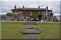
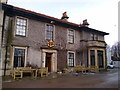
Carronvale House
Carronvale House has been the training centre for the Boy's Brigade in Scotland since 1946.
Image: © Derek Brown
Taken: 1 Jul 2011
0.11 miles
4
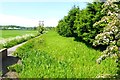
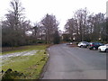
Carron works lade
Constructed in 1761 to supply the Carron Company https://en.wikipedia.org/wiki/Carron_Company with water drawn from the river upstream below Larbert kirk. See Image When the weir was breached the lade gradually silted up.
Image: © Robert Murray
Taken: 11 Jun 2015
0.19 miles