
IMAGES TAKEN NEAR TO
East Drive, LARBERT, FK5 3EL
Introduction
This page details the photographs taken nearby to East Drive, FK5 3EL by members of the Geograph project.
The Geograph project started in 2005 with the aim of publishing, organising and preserving representative images for every square kilometre of Great Britain, Ireland and the Isle of Man.

There are currently over 7.5m images from over14,400 individuals and you can help contribute to the project by visiting https://www.geograph.org.uk
Image Map
Images are licensed for reuse under creativecommons.org/licenses/by-sa/2.0
Notes
- Clicking on the map will re-center to the selected point.
- The higher the marker number, the further away the image location is from the centre of the postcode.
Image Listing (27 Images Found)
Images are licensed for reuse under creativecommons.org/licenses/by-sa/2.0
Image
Details
Distance

2
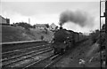
Northbound express entering Larbert Station, 1965
Headed by 61308, a Class B1 4-6-0. Designed by Edward Thompson for the LNER, the class was intended for mixed traffic work but was equally capable of handling second-rank expresses.
Image: © Alan Murray-Rust
Taken: Unknown
0.15 miles
3
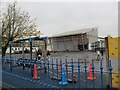
Larbert Village Primary School, rear view
The original building which opened in 1891 and faces Main Street, was extended with the building of this extension in 2009. (Front view, Image]).
Viewed here from Eastcroft Street, the extension adds 6 classrooms, an ICT suite, a new nursery class, meeting rooms and a school gymnasium to the school.
Image: © Richard Dorrell
Taken: 19 Oct 2021
0.16 miles
4
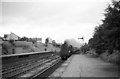
Aberdeen express passing Larbert, 1965
The Glasgow – Aberdeen expresses were the swansong of the Gresley A4 streamlined Pacific locomotives after they were displaced from the East Coast Main Line by Deltic diesels.
Image: © Alan Murray-Rust
Taken: Unknown
0.17 miles
5
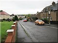
Dundarroch Street, Larbert
Residential road just south of Main Street, here looking south from close to the junction with Ronald Crescent.
Image: © Richard Dorrell
Taken: 19 Oct 2021
0.17 miles
6
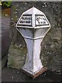
Old Milestone by the A9, Stirling Road, Larbert Bridges, Larbert parish
Stirling GM casting by the A9, in parish of Larbert (Falkirk District), Larbert, South of railway bridge, at entrance to 97-111 Falkirk Road.
Inscription reads:-
: FALKK.2Ms / EDINH.26Ms : : STIRLING / 9 MILES :
Surveyed
Milestone Society National ID: FK_FKST02
Image: © Milestone Society
Taken: Unknown
0.18 miles
7
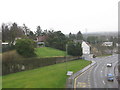
The A9 at Larbert
Looking down to Stirling Road from the railway.
Image: © M J Richardson
Taken: 9 Mar 2020
0.18 miles
8
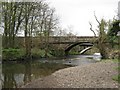
The Auld Bridge, Larbert
The bridge spans the parish boundary line between Larbert to the NE and Falkirk to the SW. (RCAHMS)
Image: © Texas Radio and The Big Beat
Taken: 25 Apr 2010
0.18 miles
9
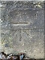
Cut mark, bench mark on western sandstone wall/gatepost good condition
Good condition cut mark, bench mark, on entrance to property in Falkirk Road. Bench Mark number BM 76.80 from OS 1:1,250/1:1,250 (1944-1970).
Image: © julie sweet
Taken: 16 Jan 2022
0.19 miles
10
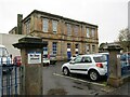
Larbert Village Primary School
This building, facing Main Street, opened in 1891 and has been refurbished twice. A new extension was built to the rear in 2009.
(See Image]).
The current pupil roll is just under 300 boys and girls aged 4 - 12.
Image: © Richard Dorrell
Taken: 19 Oct 2021
0.19 miles