
IMAGES TAKEN NEAR TO
Lamond View, LARBERT, FK5 3BW
Introduction
This page details the photographs taken nearby to Lamond View, FK5 3BW by members of the Geograph project.
The Geograph project started in 2005 with the aim of publishing, organising and preserving representative images for every square kilometre of Great Britain, Ireland and the Isle of Man.

There are currently over 7.5m images from over14,400 individuals and you can help contribute to the project by visiting https://www.geograph.org.uk
Image Map
Images are licensed for reuse under creativecommons.org/licenses/by-sa/2.0
Notes
- Clicking on the map will re-center to the selected point.
- The higher the marker number, the further away the image location is from the centre of the postcode.
Image Listing (3 Images Found)
Images are licensed for reuse under creativecommons.org/licenses/by-sa/2.0
Image
Details
Distance
1

Row of shops, Stenhousemuir
1960s row of shops and a car park.
Image: © Richard Webb
Taken: 23 Jun 2010
0.20 miles
2
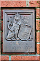
Crownest Park - plaque 1
One of two plaques sited on a pillar at what was once the entrance gate to the park from Park Drive. Locally known as "The Lido", it is not a lido as such. Crownest Park was laid out as a memorial to King George V and by the 1950s its central feature was the "children's lido" - more a pond with a sandy beach. The park is one of about 471 across the UK that were bestowed to the local communities as protected ground by King George V for outdoor and recreational purposes. The protected status should be managed by FIT (Fields in Trust), formerly the National Playing Fields Association, founded in 1925 by King George V. These plaques are found at various fields and parks around the UK to designate that the ground is protected as stated. (Information from various sources and credit given to them)
Image: © Steve Somerville
Taken: 3 Dec 2014
0.24 miles
3
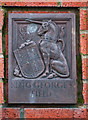
Crownest Park - plaque 2
One of two plaques sited on a pillar at what was once the entrance gate to the park from Park Drive. Locally known as "The Lido", it is not a lido as such. Crownest Park was laid out as a memorial to King George V and by the 1950s its central feature was the "children's lido" - more a pond with a sandy beach. The park is one of about 471 across UK that were bestowed to the local communities as protected ground by King George V for outdoor and recreational purposes. The protected status should be managed by FIT (Fields in Trust), formerly the National Playing Fields Association, founded in 1925 by King George V. These plaques are found at various fields and parks around the UK to designate that the ground is protected as stated. (Information from various sources and credit given to them)
Image: © Steve Somerville
Taken: 3 Dec 2014
0.24 miles