IMAGES TAKEN NEAR TO
Denny Road, LARBERT, FK5 3AD
Introduction
This page details the photographs taken nearby to Denny Road, FK5 3AD by members of the Geograph project.
The Geograph project started in 2005 with the aim of publishing, organising and preserving representative images for every square kilometre of Great Britain, Ireland and the Isle of Man.

There are currently over 7.5m images from over14,400 individuals and you can help contribute to the project by visiting https://www.geograph.org.uk
Image Map
Images are licensed for reuse under creativecommons.org/licenses/by-sa/2.0
Notes
- Clicking on the map will re-center to the selected point.
- The higher the marker number, the further away the image location is from the centre of the postcode.
Image Listing (46 Images Found)
Images are licensed for reuse under creativecommons.org/licenses/by-sa/2.0
Image
Details
Distance
1
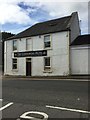
The Commercial Hotel, Larbert
Flush Bracket OSBM S4569 bottom right hand corner of main building
Image: © thejackrustles
Taken: 8 Sep 2019
0.02 miles
2
OS Flush Bracket OSBM S4569 - Larbert, Commercial Hotel
Ordnance Survey Flush Bracket OSBM S4569: Larbert, Commercial Hotel
Image: © thejackrustles
Taken: 8 Sep 2019
0.02 miles
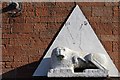
3
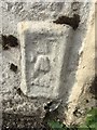
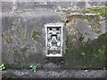
Ordnance Survey Flush Bracket S4569
This heavily over-painted bracket can be found on a roadside wall of the Commercial Hotel in Larbert. The benchmark height is recorded as being 31.577 metres above sea level. For more detail see : http://www.bench-marks.org.uk/bm19278
Image: © Peter Wood
Taken: 29 Sep 2017
0.02 miles
4
The Tea House Chinese Restaurant, Larbert Cross
Formerly The Red Lion Hotel
Image: © Leslie Barrie
Taken: 10 Oct 2013
0.03 miles
5
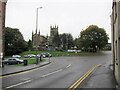
Cross roads, Larbert
The photographer is standing in Main Street, looking south-west. Vehicles are queueing at the traffic lights in Stirling Road. Larbert Old Church stands beyond the junction.
Image: © Richard Dorrell
Taken: 19 Oct 2021
0.04 miles
6
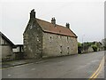
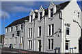
Old Manse, Larbert
Located in Denny Road. The building is dated 1635, and was restored in 1955, when the pantile roof was installed.
Image: © Richard Dorrell
Taken: 19 Oct 2021
0.04 miles
7
Stone Lion, Larbert Cross
According to a local, this sculpture was originally intended for the original Red Lion Hotel which was situated on Main Street on the same side of the road a few buildings to the east. This can be seen on old OS Maps. The original Red Lion was demolished.
Image: © Leslie Barrie
Taken: 10 Oct 2013
0.05 miles
8
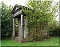
Dawson Family Mausoleum
Inside is the most amazing statue which can be clearly seen through the door,
as described here...
"In the north-west corner of the churchyard an iron railing, of good height, surrounds the burial-place of the Carron family. Within the enclosure stands a tasteful obelisk of granite to the memory of Joseph Dawson, who was manager for the company, from 1825 to 1850; and immediately behind this is a structure, chaste and simple, to Joseph Stainton, who preceded Mr. Dawson in office, while on the south side a mausoleum, in the form of a small Greek temple of elegant proportions, has been erected over the grave of William Dawson, late manager of the works. At one end is a gate of beautiful bronze work, having an open lattice in its upper half, through which a view may be had of the interior. In this shrine, or cella, which is lighted from the roof, a marble statue, representing the "Angel of the Resurrection" was placed a few months ago. Carved out of a speckled block of white marble, the statue rests on a low basement of bluish grey Sicilian, harmonising in style with the architecture of the mausoleum. The figure, which is on a scale somewhat larger than life, has been designed in a sitting posture, body and limbs being draped in a loose robe, through which the contours are freely expressed. The right hand grasps a straight trumpet, which is held in a diagonal position across the breast, while the left rests easily on a closed book lying upon the lap. The head is held erect, with an upward look that indicates expectancy, and with this the whole attitude happily corresponds, the disposition of the lower limbs bespeaking readiness to rise on the giving of the watched-for signal."
History of Stirlingshire Chapter XIX. Larbert
The statue described above has now been photographed www.geograph.org.uk/photo/2567027
Image: © Texas Radio and The Big Beat
Taken: 1 May 2010
0.05 miles
9
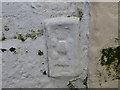
Ordnance Survey Flush Bracket S4568
This bracket can be found on the wall of the Old Church in Larbert. The benchmark height is recorded as being 31.645 metres above sea level. For more detail see : http://www.bench-marks.org.uk/bm12424
Image: © Peter Wood
Taken: 29 Sep 2017
0.05 miles
10
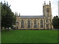
The Old Church at Larbert
Viewed from the north.
Image: © Peter Wood
Taken: 29 Sep 2017
0.05 miles