IMAGES TAKEN NEAR TO
BONNYBRIDGE, FK4 2HH
Introduction
This page details the photographs taken nearby to FK4 2HH by members of the Geograph project.
The Geograph project started in 2005 with the aim of publishing, organising and preserving representative images for every square kilometre of Great Britain, Ireland and the Isle of Man.

There are currently over 7.5m images from over14,400 individuals and you can help contribute to the project by visiting https://www.geograph.org.uk
Image Map
Images are licensed for reuse under creativecommons.org/licenses/by-sa/2.0
Notes
- Clicking on the map will re-center to the selected point.
- The higher the marker number, the further away the image location is from the centre of the postcode.
Image Listing (4 Images Found)
Images are licensed for reuse under creativecommons.org/licenses/by-sa/2.0
Image
Details
Distance
1
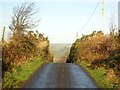
Over the braes to Allandale
Typical piece of road engineering to reduce the incline in the days when carts were the kings of the road.
Image: © Robert Murray
Taken: 13 Jan 2012
0.13 miles
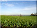
4
![Burnhouse, grazing land [2]](https://s2.geograph.org.uk/geophotos/02/77/10/2771082_c6004576_120x120.jpg)
Burnhouse, grazing land [2]
View south of the farm into a huge field which extends well over the horizon.
Image: © Robert Murray
Taken: 13 Jan 2012
0.23 miles