IMAGES TAKEN NEAR TO
BONNYBRIDGE, FK4 2HB
Introduction
This page details the photographs taken nearby to FK4 2HB by members of the Geograph project.
The Geograph project started in 2005 with the aim of publishing, organising and preserving representative images for every square kilometre of Great Britain, Ireland and the Isle of Man.

There are currently over 7.5m images from over14,400 individuals and you can help contribute to the project by visiting https://www.geograph.org.uk
Image Map
Images are licensed for reuse under creativecommons.org/licenses/by-sa/2.0
Notes
- Clicking on the map will re-center to the selected point.
- The higher the marker number, the further away the image location is from the centre of the postcode.
Image Listing (10 Images Found)
Images are licensed for reuse under creativecommons.org/licenses/by-sa/2.0
Image
Details
Distance
1
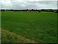
Farmland near Antonine Wall
Almost ready for second cut of silage
Image: © Jim Smillie
Taken: 29 Jun 2023
0.15 miles
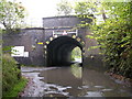
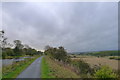
2

View over canal
The B816 is very close to the canal at this point
Image: © Jim Smillie
Taken: 29 Jun 2023
0.16 miles
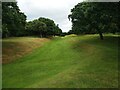
3
Forth and Clyde Canal
Eastward view through grasslands.
Image: © Richard Webb
Taken: 24 Aug 2009
0.21 miles
4
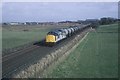
An oil train from Grangemouth
Oil from Grangemouth en-route to Bishopbriggs oil depot. This flow finished not long after this picture was taken. The train had to run via a circular route to access the oil terminal at Bishopsbrigg, it was much quicker as the crow flew!
Image: © roger geach
Taken: 11 Mar 1994
0.23 miles
5

A Train Passing Near Greenhill
A train passes over this old bridge on the Glasgow - Edinburgh line.
Image: © Texas Radio and The Big Beat
Taken: 3 May 2010
0.24 miles
6
The John Muir Way alongside the Forth and Clyde Canal
With the valley of Bonny Water to the right.
The 134 mile John Muir Way, running coast to coast across Scotland's Central Belt, celebrates the Dunbar-born Scotsman who emigrated to America aged 11. Here his love of nature led him to become a leading advocate for the preservation of wilderness areas. He is often referred to as 'the father of national parks'
Image: © Tim Heaton
Taken: 8 Oct 2018
0.24 miles
7
Antonine Wall: Ditch
Lots of oak trees on either side
Image: © Jim Smillie
Taken: 29 Jun 2023
0.24 miles
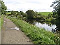
8
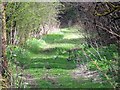
Underwood, track
Runs alongside the bottom of the canal banking to provide access to the fields lining the Bonny Water.
Image: © Robert Murray
Taken: 9 Apr 2011
0.25 miles