IMAGES TAKEN NEAR TO
Hoggan Court, BONNYBRIDGE, FK4 1UJ
Introduction
This page details the photographs taken nearby to Hoggan Court, FK4 1UJ by members of the Geograph project.
The Geograph project started in 2005 with the aim of publishing, organising and preserving representative images for every square kilometre of Great Britain, Ireland and the Isle of Man.

There are currently over 7.5m images from over14,400 individuals and you can help contribute to the project by visiting https://www.geograph.org.uk
Image Map
Images are licensed for reuse under creativecommons.org/licenses/by-sa/2.0
Notes
- Clicking on the map will re-center to the selected point.
- The higher the marker number, the further away the image location is from the centre of the postcode.
Image Listing (22 Images Found)
Images are licensed for reuse under creativecommons.org/licenses/by-sa/2.0
Image
Details
Distance
2
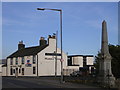
Masonic Arms and War Memorial, Longcroft
Image: © Chris Upson
Taken: 5 May 2006
0.08 miles
4
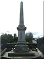
Longcroft war memorial
The war memorial at Longcroft was unveiled on 25th June 1921.
Image: © Euan Nelson
Taken: 24 Feb 2018
0.12 miles
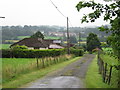
5

Road Junction in Longcroft
Though difficult to believe now, prior to the building of the M80, in the 1960s, the road branching off to the left was the main road, indeed it was the A80 to Glasgow.
Image: © G Laird
Taken: 12 Jun 2012
0.13 miles
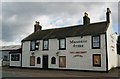
8

The Masonic Arms
Now rebranded "The Inn at Longcroft".
Image: © Richard Webb
Taken: 10 Sep 2011
0.14 miles
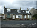
9
The Masonic Arms (unoccupied)
Known to locals as "Alastairs".
Image: © Texas Radio and The Big Beat
Taken: 29 Aug 2010
0.14 miles
10
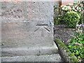
Ordnance Survey Cut Mark with Bolt
This mark and bolt can be found on the wall of Haggs Parish Church.
The recorded details give a height of 61.25 metres above sea level.
For more detail see : https://www.bench-marks.org.uk/bm37205
Image: © Peter Wood
Taken: 3 Sep 2022
0.16 miles