IMAGES TAKEN NEAR TO
Bankier Road, BONNYBRIDGE, FK4 1TF
Introduction
This page details the photographs taken nearby to Bankier Road, FK4 1TF by members of the Geograph project.
The Geograph project started in 2005 with the aim of publishing, organising and preserving representative images for every square kilometre of Great Britain, Ireland and the Isle of Man.

There are currently over 7.5m images from over14,400 individuals and you can help contribute to the project by visiting https://www.geograph.org.uk
Image Map
Images are licensed for reuse under creativecommons.org/licenses/by-sa/2.0
Notes
- Clicking on the map will re-center to the selected point.
- The higher the marker number, the further away the image location is from the centre of the postcode.
Image Listing (15 Images Found)
Images are licensed for reuse under creativecommons.org/licenses/by-sa/2.0
Image
Details
Distance
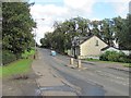
2
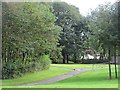
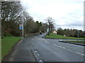
Open space, Banknock
An area of wooded parkland, either side of the Kilsyth Road.
Image: © Richard Webb
Taken: 10 Sep 2011
0.06 miles
3
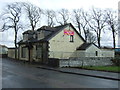
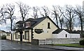
Business opportunity on Kilsyth Road, Banknock
The former Holland Bush Inn.
Image: © JThomas
Taken: 30 Mar 2017
0.06 miles
4
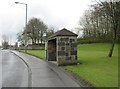
Bus Stop, Banknock
An old and built-to-last bus stop on Kilsyth Road.
Image: © Texas Radio and The Big Beat
Taken: 25 Apr 2010
0.07 miles
5
The Hollandbush Inn, Banknock
Image: © Texas Radio and The Big Beat
Taken: 25 Apr 2010
0.07 miles
6
Banknock Store, Bog Road, Banknock
The stream is Doups Burn
Image: © Tim Heaton
Taken: 9 Oct 2018
0.08 miles
8
Roundabout on the A803, Banknock
Looking east.
Image: © JThomas
Taken: 30 Mar 2017
0.11 miles
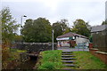
10
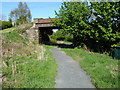
Banknock Railway Station
The Kilsyth and Bonnybridge Railway had a station here at Banknock but it didn't last long, it was closed in 1956 and when freight trains stopped in 1964, it was really the end of the line. The local council have turned the route into a path.
Image: © Raymond Okonski
Taken: 30 Apr 2007
0.16 miles