IMAGES TAKEN NEAR TO
Singers Place, BONNYBRIDGE, FK4 1FD
Introduction
This page details the photographs taken nearby to Singers Place, FK4 1FD by members of the Geograph project.
The Geograph project started in 2005 with the aim of publishing, organising and preserving representative images for every square kilometre of Great Britain, Ireland and the Isle of Man.

There are currently over 7.5m images from over14,400 individuals and you can help contribute to the project by visiting https://www.geograph.org.uk
Image Map
Images are licensed for reuse under creativecommons.org/licenses/by-sa/2.0
Notes
- Clicking on the map will re-center to the selected point.
- The higher the marker number, the further away the image location is from the centre of the postcode.
Image Listing (7 Images Found)
Images are licensed for reuse under creativecommons.org/licenses/by-sa/2.0
Image
Details
Distance
1
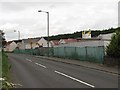
Heathfield
The anodyne name Heathfield tells you it's a modern housing development. This one by Barratt fills the gap between Bonnybridge and Dennyloanhead. The M876 runs behind it.
Image: © Richard Webb
Taken: 23 Jun 2010
0.06 miles

3
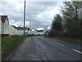
Bonnybridge Road (A803)
Looking north east.
Image: © JThomas
Taken: 30 Mar 2017
0.09 miles
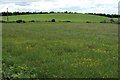
4

Bonnyfield Nature Park
A woodland and meadow area between Bonnybridge and Dennyloanhead.
Image: © Richard Webb
Taken: 23 Jun 2010
0.11 miles
6
Field beside Drove Loan
Of the two fields visible here, the more distant one has, at its highest point, a small modern structure; in this photograph, that structure is positioned centrally on the skyline.
The area around that structure is of archaeological interest, and, in 1996, was granted legal protection as a scheduled monument. See https://canmore.org.uk/site/47007/wheatlands (at Canmore) for details of the traces of a prehistoric settlement found there; the settlement was surrounded by an oval enclosure.
In the report just cited, an OS representative (a ground-based observer) states, in 1974, that no traces are visible. However, at the time of submission, the outline of the oval enclosure can still be discerned on satellite imagery; for such an image, which I have annotated to show the outline of the enclosure, see https://www.google.com/maps/d/viewer?mid=1XT6lTkLb5_Vy9C6vCMSSERxzUww&ll=56.005130964554866%2C-3.8994382662010594&z=19
For a more distant view, and for a discussion of Drove Loan itself (and its name in particular), see Image
Image: © Lairich Rig
Taken: 14 Jun 2010
0.24 miles
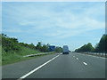
7
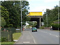
Yellow Lorry
Crossing the motorway bridge that carries the M876 across the A872.
Image: © James Allan
Taken: 13 Jul 2006
0.25 miles