IMAGES TAKEN NEAR TO
Smeaton Drive, BONNYBRIDGE, FK4 1AS
Introduction
This page details the photographs taken nearby to Smeaton Drive, FK4 1AS by members of the Geograph project.
The Geograph project started in 2005 with the aim of publishing, organising and preserving representative images for every square kilometre of Great Britain, Ireland and the Isle of Man.

There are currently over 7.5m images from over14,400 individuals and you can help contribute to the project by visiting https://www.geograph.org.uk
Image Map
Images are licensed for reuse under creativecommons.org/licenses/by-sa/2.0
Notes
- Clicking on the map will re-center to the selected point.
- The higher the marker number, the further away the image location is from the centre of the postcode.
Image Listing (9 Images Found)
Images are licensed for reuse under creativecommons.org/licenses/by-sa/2.0
Image
Details
Distance
2

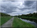
The Forth and Clyde Canal approaching Bonnybridge
The autumn colours haven't quite started yet
Image: © Tim Heaton
Taken: 8 Oct 2018
0.10 miles
3
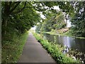
Forth & Clyde Canal, towpath
View along the towpath to the east from near Bonnybridge Hospital.
Image: © Robert Murray
Taken: 20 Jun 2011
0.13 miles
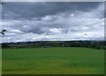
4
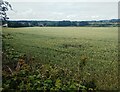
Field of Wheat
Stretching from canal to A803
Image: © Jim Smillie
Taken: 29 Jun 2023
0.16 miles
5
Forth and Clyde Canal
Eastwards out of Bonnybridge.
Image: © Richard Webb
Taken: 30 Aug 2024
0.18 miles

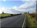
7
Bonnybridge, fields
Probably belonging to Wester Carmuirs Farm.
Image: © Robert Murray
Taken: 20 Jun 2011
0.21 miles
9
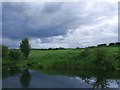
Forth & Clyde Canal, Bonnyside
Fields south of the canal.
Image: © Robert Murray
Taken: 20 Jun 2011
0.25 miles