IMAGES TAKEN NEAR TO
Bo'Ness Road, GRANGEMOUTH, FK3 9UR
Introduction
This page details the photographs taken nearby to Bo'Ness Road, FK3 9UR by members of the Geograph project.
The Geograph project started in 2005 with the aim of publishing, organising and preserving representative images for every square kilometre of Great Britain, Ireland and the Isle of Man.

There are currently over 7.5m images from over14,400 individuals and you can help contribute to the project by visiting https://www.geograph.org.uk
Image Map
Images are licensed for reuse under creativecommons.org/licenses/by-sa/2.0
Notes
- Clicking on the map will re-center to the selected point.
- The higher the marker number, the further away the image location is from the centre of the postcode.
Image Listing (6 Images Found)
Images are licensed for reuse under creativecommons.org/licenses/by-sa/2.0
Image
Details
Distance
2
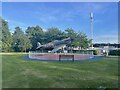
Grangemouth Spitfire Memorial
A full size replica spitfire beside Bo'ness Road (A904), Grangemouth.
A tribute to 71 pilots who died while learning to fly at RAF Grangemouth.
Image: © JThomas
Taken: 21 Jun 2017
0.08 miles
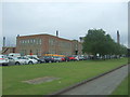
3
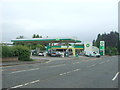
Service station on Bo'ness Road (A904), Grangemouth
Image: © JThomas
Taken: 21 Jun 2017
0.11 miles
4
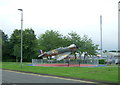
Disused railway, Grangemouth
Partly obstructed railway at the petrochemical works, Grangemouth
Image: © Richard Webb
Taken: 15 Sep 2011
0.12 miles
6
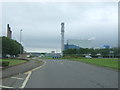
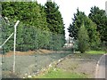
Bo'ness Road (A904), Grangemouth
Looking south east - approaching roundabout.
Image: © JThomas
Taken: 21 Jun 2017
0.22 miles