IMAGES TAKEN NEAR TO
George Street, GRANGEMOUTH, FK3 9AG
Introduction
This page details the photographs taken nearby to George Street, FK3 9AG by members of the Geograph project.
The Geograph project started in 2005 with the aim of publishing, organising and preserving representative images for every square kilometre of Great Britain, Ireland and the Isle of Man.

There are currently over 7.5m images from over14,400 individuals and you can help contribute to the project by visiting https://www.geograph.org.uk
Image Map
Images are licensed for reuse under creativecommons.org/licenses/by-sa/2.0
Notes
- Clicking on the map will re-center to the selected point.
- The higher the marker number, the further away the image location is from the centre of the postcode.
Image Listing (13 Images Found)
Images are licensed for reuse under creativecommons.org/licenses/by-sa/2.0
Image
Details
Distance
1
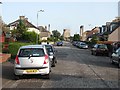
Oswald Drive, Grangemouth
You can smell the petrochemical works too.
Image: © Richard Webb
Taken: 15 Sep 2011
0.10 miles
2
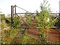
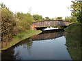
Former railway bridge, Grangemouth refinery
The bridge carried a railway, now disused, over the Grange Burn into the refinery.
Image: © Richard Webb
Taken: 15 Sep 2011
0.14 miles
3
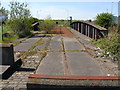
End of the line at Grangemouth
These twin tracks used to provide a vital link in moving refined oil to all parts of the UK by rail. Whilst it appears these days are no more with road transport now the preferred method of bulk distribution, these incoming tracks to the former BP Oil Refinery at Grangemouth and the extensive sidings behind lie empty and disused - it's not all bad news. A SECOND rail connection (single track) in Image still allows trains to enter the INEOS refinery.
Image: © Raymond Okonski
Taken: 30 Apr 2007
0.14 miles
5
Grange Burn
The railway which once served the oil refinery crossed the Grange Burn at the iron bridge. The line is now closed and blocked in places.
Image: © Richard Webb
Taken: 15 Sep 2011
0.15 miles
7
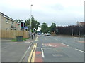
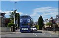
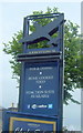
Road junction on Bo'ness Road (A904), Grangemouth
Looking south east.
Image: © JThomas
Taken: 21 Jun 2017
0.16 miles
8
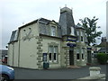
The Abbotsinch, Grangemouth
Public house on Bo'ness Road.
Image: © JThomas
Taken: 21 Jun 2017
0.16 miles
10
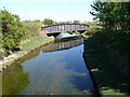
Oil Refinery Bridge & River Grange
This twin-track railway bridge was the primary access for rail wagons to reach the BP Oil Refinery at Grangemouth. It is now disused. The river passing under the bridge is the Grange, and gave the area its name - being located close to the mouth of the river, hence Grange-mouth.
Image: © Raymond Okonski
Taken: 30 Apr 2007
0.17 miles