IMAGES TAKEN NEAR TO
Tedder Street, GRANGEMOUTH, FK3 8SH
Introduction
This page details the photographs taken nearby to Tedder Street, FK3 8SH by members of the Geograph project.
The Geograph project started in 2005 with the aim of publishing, organising and preserving representative images for every square kilometre of Great Britain, Ireland and the Isle of Man.

There are currently over 7.5m images from over14,400 individuals and you can help contribute to the project by visiting https://www.geograph.org.uk
Image Map
Images are licensed for reuse under creativecommons.org/licenses/by-sa/2.0
Notes
- Clicking on the map will re-center to the selected point.
- The higher the marker number, the further away the image location is from the centre of the postcode.
Image Listing (12 Images Found)
Images are licensed for reuse under creativecommons.org/licenses/by-sa/2.0
Image
Details
Distance
2
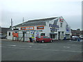
Shops, Newlands Road
Unlike many others who planned large housing estates those who designed Grangemouth scattered several small groups of shops amongst the houses.
Image: © Tom Sargent
Taken: 27 Dec 2008
0.11 miles
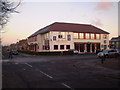
4
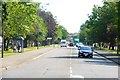
Grangemouth, street scene
View to Newlands Road.
Image: © Robert Murray
Taken: 1 Jul 2015
0.12 miles
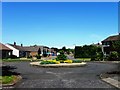
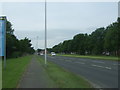
9
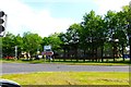
Grangemouth, road junction
Street scene where a slip road comes off the M9.
Image: © Robert Murray
Taken: 1 Jul 2015
0.16 miles
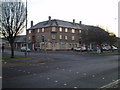
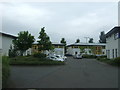
10
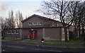
Community Centre
Used by many local groups
Image: © Tom Sargent
Taken: 27 Dec 2008
0.20 miles