IMAGES TAKEN NEAR TO
Waverley Crescent, GRANGEMOUTH, FK3 8RB
Introduction
This page details the photographs taken nearby to Waverley Crescent, FK3 8RB by members of the Geograph project.
The Geograph project started in 2005 with the aim of publishing, organising and preserving representative images for every square kilometre of Great Britain, Ireland and the Isle of Man.

There are currently over 7.5m images from over14,400 individuals and you can help contribute to the project by visiting https://www.geograph.org.uk
Image Map
Images are licensed for reuse under creativecommons.org/licenses/by-sa/2.0
Notes
- Clicking on the map will re-center to the selected point.
- The higher the marker number, the further away the image location is from the centre of the postcode.
Image Listing (11 Images Found)
Images are licensed for reuse under creativecommons.org/licenses/by-sa/2.0
Image
Details
Distance
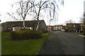
1
TA Centre
This is a mobile unit so the building on the right is a garage
Image: © Tom Sargent
Taken: 27 Dec 2008
0.07 miles
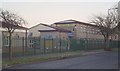
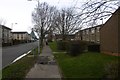
2
Community Centre
Used by many local groups
Image: © Tom Sargent
Taken: 27 Dec 2008
0.10 miles
3
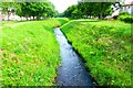
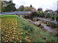
Grangemouth, the Grange Burn
With the town lying on the carse levies are a must to enclose water courses.
Image: © Robert Murray
Taken: 1 Jul 2015
0.17 miles
4
Grange Burn
Grange Burn at the south entrance to Zetland Park, Grangemouth.
This is the burn that gives Grangemouth its name, though the last few kilometres of the Grange Burn are now canalised so it enters the Forth at a different place from years ago. Grangemouth was originally called Sealock.
Image: © Adam Ward
Taken: 26 Oct 2006
0.19 miles
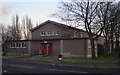
5
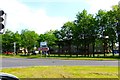
Grangemouth, road junction
Street scene where a slip road comes off the M9.
Image: © Robert Murray
Taken: 1 Jul 2015
0.20 miles
7
![Grangemouth, Flood Relief [2]](https://s3.geograph.org.uk/geophotos/04/55/09/4550903_f91c121e_120x120.jpg)
Grangemouth, Flood Relief [2]
The Polmont burn heads east in its artificial channel towards the Avon.
Image: © Robert Murray
Taken: 1 Jul 2015
0.22 miles
8
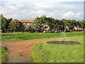
Swings, Rannoch Park
Beyond the isolated swings, are the embankments containing the Grange Burn.
Image: © Richard Webb
Taken: 4 Sep 2009
0.23 miles
9
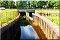
Grangemouth, Flood Relief
Two burns align here under the A905 but have been separated by hard engineering as they emerge form under the roadway. The burn on the left is the Polmont burn and on the right the Glen burn (which at this point in turn becomes the Grange burn). This is part of low lying Grangemouth's flood control scheme. After heavy rainfall when both burns are in spate the Glen burn spills over into the channel of the Polmont burn - which is then taken away in a diversion canal towards the river Avon a couple of miles away. See Image
Image: © Robert Murray
Taken: 1 Jul 2015
0.23 miles