IMAGES TAKEN NEAR TO
Cedar Street, GRANGEMOUTH, FK3 8NG
Introduction
This page details the photographs taken nearby to Cedar Street, FK3 8NG by members of the Geograph project.
The Geograph project started in 2005 with the aim of publishing, organising and preserving representative images for every square kilometre of Great Britain, Ireland and the Isle of Man.

There are currently over 7.5m images from over14,400 individuals and you can help contribute to the project by visiting https://www.geograph.org.uk
Image Map
Images are licensed for reuse under creativecommons.org/licenses/by-sa/2.0
Notes
- Clicking on the map will re-center to the selected point.
- The higher the marker number, the further away the image location is from the centre of the postcode.
Image Listing (5 Images Found)
Images are licensed for reuse under creativecommons.org/licenses/by-sa/2.0
Image
Details
Distance
2
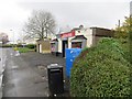
General store, Orchard Street
Shop in residential Grangemouth.
Image: © Richard Webb
Taken: 28 Nov 2014
0.17 miles
4
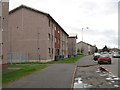
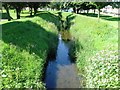
Flats, Kingseat Avenue
On the south side of the street with a bridge over the Grange Burn in the background.
Image: © Richard Webb
Taken: 4 Sep 2009
0.21 miles
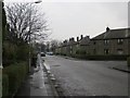
5
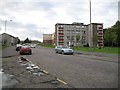
Flats, Kingseat Avenue
Some small blocks of flats built on the edge of Zetland Park.
Image: © Richard Webb
Taken: 4 Sep 2009
0.23 miles