IMAGES TAKEN NEAR TO
Craigleith Road, GRANGEMOUTH, FK3 0AZ
Introduction
This page details the photographs taken nearby to Craigleith Road, FK3 0AZ by members of the Geograph project.
The Geograph project started in 2005 with the aim of publishing, organising and preserving representative images for every square kilometre of Great Britain, Ireland and the Isle of Man.

There are currently over 7.5m images from over14,400 individuals and you can help contribute to the project by visiting https://www.geograph.org.uk
Image Map
Images are licensed for reuse under creativecommons.org/licenses/by-sa/2.0
Notes
- Clicking on the map will re-center to the selected point.
- The higher the marker number, the further away the image location is from the centre of the postcode.
Image Listing (20 Images Found)
Images are licensed for reuse under creativecommons.org/licenses/by-sa/2.0
Image
Details
Distance
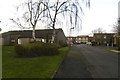
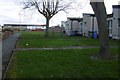
3
Green space, Sealock Court
Bowhouse, Grangemouth.
Image: © Richard Webb
Taken: 9 Mar 2017
0.10 miles
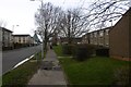
5
Off Myreton Road
Bowhouse, Grangemouth.
Image: © Richard Webb
Taken: 9 Mar 2017
0.13 miles

8
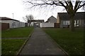
Between Skye Court and Myreton Road.
Bowhouse, Grangemouth.
Image: © Richard Webb
Taken: 9 Mar 2017
0.17 miles
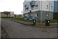
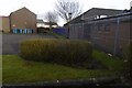
9
Albert Gospel Hall
With large car park. Former school building?
Image: © Richard Webb
Taken: 9 Mar 2017
0.17 miles
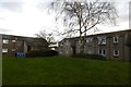
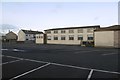
10
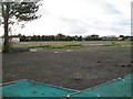
Grangemouth High School, former site
The site of the previous school buildings, vacated in December 2008 when the school moved to adjacent new buildings.
Image: © Richard Webb
Taken: 4 Sep 2009
0.17 miles