IMAGES TAKEN NEAR TO
Aven Drive, FALKIRK, FK2 9QD
Introduction
This page details the photographs taken nearby to Aven Drive, FK2 9QD by members of the Geograph project.
The Geograph project started in 2005 with the aim of publishing, organising and preserving representative images for every square kilometre of Great Britain, Ireland and the Isle of Man.

There are currently over 7.5m images from over14,400 individuals and you can help contribute to the project by visiting https://www.geograph.org.uk
Image Map
Images are licensed for reuse under creativecommons.org/licenses/by-sa/2.0
Notes
- Clicking on the map will re-center to the selected point.
- The higher the marker number, the further away the image location is from the centre of the postcode.
Image Listing (16 Images Found)
Images are licensed for reuse under creativecommons.org/licenses/by-sa/2.0
Image
Details
Distance
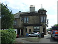
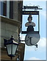
1
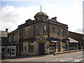
Lauries Bar & Restaurant, Laurieston
On Mary Street.
Image: © JThomas
Taken: 25 May 2017
0.07 miles
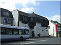
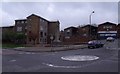
4
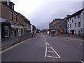
Laurieston looking west
The spire on the horizon centrally is Falkirk's Information centre
Image: © Tom Sargent
Taken: 14 Apr 2009
0.10 miles
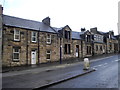
9
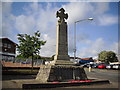
Laurieston War Memorial
An ordinary small town - but a long list of names.
Image: © Tom Sargent
Taken: 14 Apr 2009
0.13 miles