IMAGES TAKEN NEAR TO
Aitken Crescent, FALKIRK, FK2 9GL
Introduction
This page details the photographs taken nearby to Aitken Crescent, FK2 9GL by members of the Geograph project.
The Geograph project started in 2005 with the aim of publishing, organising and preserving representative images for every square kilometre of Great Britain, Ireland and the Isle of Man.

There are currently over 7.5m images from over14,400 individuals and you can help contribute to the project by visiting https://www.geograph.org.uk
Image Map
Images are licensed for reuse under creativecommons.org/licenses/by-sa/2.0
Notes
- Clicking on the map will re-center to the selected point.
- The higher the marker number, the further away the image location is from the centre of the postcode.
Image Listing (21 Images Found)
Images are licensed for reuse under creativecommons.org/licenses/by-sa/2.0
Image
Details
Distance
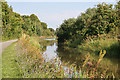
2
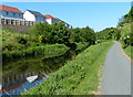
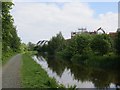
The John Muir Way, and National Cycle Route 754 alongside the Union Canal
The towpath was being well used; the canal less so.
Image: © Tim Heaton
Taken: 4 Jul 2018
0.15 miles
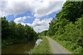
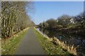
3
Union Canal between Polmont and Falkirk
The canal which I am following westward near Bridge No 57.
Image: © Chris Heaton
Taken: 9 Aug 2009
0.15 miles
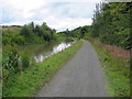
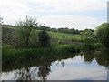
5
Union Canal
Looking eastwards towards the site of Reddings Colliery. There is a lot of house building taking place on the south side of the canal.
Image: © Richard Webb
Taken: 30 May 2014
0.16 miles
6
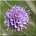
Devils' Bit Scabious (Succisa pratensis)
There were quite a few of these late summer flowers along the towpath.
Image: © Anne Burgess
Taken: 26 Aug 2013
0.16 miles
7
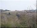
Callendar Rise
Huge housing development southwest of Redding. The railway runs between Falkirk Grahamston and Polmont and serves Edinburgh and Stirling.
Image: © Richard Webb
Taken: 3 Apr 2009
0.16 miles
8
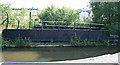
Swivel Bridge
The curved edge of the towpath was what alerted me to the existence of this disused swivel bridge, which used to carry an industrial railway over the canal. It clearly post-dates the construction of the canal, but it is shown on the six-inch map which was surveyed in 1860. See also Image
Image: © Anne Burgess
Taken: 26 Aug 2013
0.16 miles
9
A Peaceful Scene
Just a few hundred metres from the industrial estate, young offenders' institution, caravan site and mushrooming housing developments, and it's as if you are miles from anywhere. Notice the blue flowers of Image] all along the canal bank.
Image: © Anne Burgess
Taken: 26 Aug 2013
0.17 miles
10
Land awaiting development
A field to the south of the Union Canal, now on the edge of a big new housing development.
Image: © Richard Webb
Taken: 30 May 2014
0.18 miles