IMAGES TAKEN NEAR TO
Grangemouth Road, FALKIRK, FK2 9AA
Introduction
This page details the photographs taken nearby to Grangemouth Road, FK2 9AA by members of the Geograph project.
The Geograph project started in 2005 with the aim of publishing, organising and preserving representative images for every square kilometre of Great Britain, Ireland and the Isle of Man.

There are currently over 7.5m images from over14,400 individuals and you can help contribute to the project by visiting https://www.geograph.org.uk
Image Map
Images are licensed for reuse under creativecommons.org/licenses/by-sa/2.0
Notes
- Clicking on the map will re-center to the selected point.
- The higher the marker number, the further away the image location is from the centre of the postcode.
Image Listing (12 Images Found)
Images are licensed for reuse under creativecommons.org/licenses/by-sa/2.0
Image
Details
Distance
1
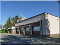
Falkirk ambulance station, Grangemouth Road
This is a "community" ambulance station, I don't know whether that means the crews are volunteers. I thought it looked more like a traditional fire station in its design, and indeed the Facebook page for the station says "it used to be the old fire station building which has now been given a new lease of life by the ambulance service".
Image: © Stephen Craven
Taken: 27 Jun 2019
0.03 miles
2
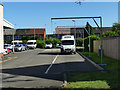
Falkirk ambulance station - charging points
I presume the electrical sockets here are for charging the batteries used by on-board electrical equipment. See Image for the building.
Image: © Stephen Craven
Taken: 27 Jun 2019
0.04 miles
3
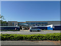
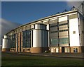
New building for Forth Valley College
The building appeared to be nearing completion in the summer of 2019.
Image: © Stephen Craven
Taken: 27 Jun 2019
0.09 miles
5
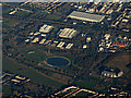
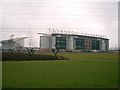
The Helix from the air
Falkirk Stadium (home of Falkirk FC) can be seen on the right.
Image: © Thomas Nugent
Taken: 4 Dec 2016
0.14 miles
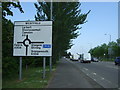
6
Westfield roundabout, Falkirk
The junction between the A9 Falkirk bypass that runs roughly north-south at this point, and the east-west A904 that links the town with the M9 motorway.
Image: © Stephen Craven
Taken: 27 Jun 2019
0.15 miles
7
A9 towards Stenhousemuir
Looking north west.
Image: © JThomas
Taken: 25 May 2017
0.16 miles
8
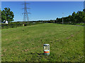
Oil pipeline marker by Westfield roundabout
Not surprising, since this is close to the Grangemouth oil terminal.
Image: © Stephen Craven
Taken: 27 Jun 2019
0.18 miles
9
Falkirk Stadium
Frontage of the main stand at Falkirk Stadium, home of Falkirk FC (currently in the Scottish Premier League, season 06-07). The stadium has also been used for youth internationals, and Scotland U21 rugby internationals. It replaced the previous town centre stadium, Brockville Park, which is now the site of a supermarket.
Image: © David Neill
Taken: 1 Oct 2005
0.20 miles
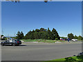
10
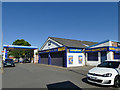
McConechy's filling station and tyre services
On Grangemouth Road, Falkirk.
Image: © Stephen Craven
Taken: 27 Jun 2019
0.23 miles