IMAGES TAKEN NEAR TO
Bothkennar, FALKIRK, FK2 8PA
Introduction
This page details the photographs taken nearby to FK2 8PA by members of the Geograph project.
The Geograph project started in 2005 with the aim of publishing, organising and preserving representative images for every square kilometre of Great Britain, Ireland and the Isle of Man.

There are currently over 7.5m images from over14,400 individuals and you can help contribute to the project by visiting https://www.geograph.org.uk
Image Map
Images are licensed for reuse under creativecommons.org/licenses/by-sa/2.0
Notes
- Clicking on the map will re-center to the selected point.
- The higher the marker number, the further away the image location is from the centre of the postcode.
Image Listing (21 Images Found)
Images are licensed for reuse under creativecommons.org/licenses/by-sa/2.0
Image
Details
Distance
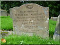
2
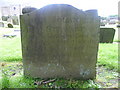
18thC gravestone, Bothkennar
For the other side of this stone, see Image
Image: © kim traynor
Taken: 12 Aug 2010
0.19 miles
3
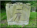
18thC gravestone, Bothkennar
For the other side of this stone, see Image
Image: © kim traynor
Taken: 12 Aug 2010
0.19 miles
5
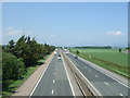
M9 towards Stirling
Looking north west from the bridge on Bothkennar Road.
Image: © JThomas
Taken: 25 May 2017
0.19 miles