IMAGES TAKEN NEAR TO
Westerton Terrace, FALKIRK, FK2 8HP
Introduction
This page details the photographs taken nearby to Westerton Terrace, FK2 8HP by members of the Geograph project.
The Geograph project started in 2005 with the aim of publishing, organising and preserving representative images for every square kilometre of Great Britain, Ireland and the Isle of Man.

There are currently over 7.5m images from over14,400 individuals and you can help contribute to the project by visiting https://www.geograph.org.uk
Image Map
Images are licensed for reuse under creativecommons.org/licenses/by-sa/2.0
Notes
- Clicking on the map will re-center to the selected point.
- The higher the marker number, the further away the image location is from the centre of the postcode.
Image Listing (17 Images Found)
Images are licensed for reuse under creativecommons.org/licenses/by-sa/2.0
Image
Details
Distance
1
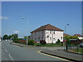
Pink houses on North Main Street, Carronshore
Image: © JThomas
Taken: 25 May 2017
0.06 miles
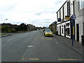
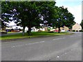
2
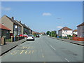
Bus stop on North Main Street, Carronshore
Looking north.
Image: © JThomas
Taken: 25 May 2017
0.06 miles

6
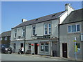
The Victoria Inn, Carronshore
On North Main Street.
Image: © JThomas
Taken: 25 May 2017
0.09 miles
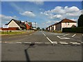
9
Victoria Inn
Pub with a handy bus stop, in Castle Avenue, Carronshore.
Image: © James Allan
Taken: 8 Jul 2006
0.13 miles
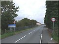
10
Carronshore, Main Street
It's a well kept wee place the 'Shore.
Image: © Robert Murray
Taken: 17 Jul 2014
0.13 miles