IMAGES TAKEN NEAR TO
Burnside Place, FALKIRK, FK2 8ER
Introduction
This page details the photographs taken nearby to Burnside Place, FK2 8ER by members of the Geograph project.
The Geograph project started in 2005 with the aim of publishing, organising and preserving representative images for every square kilometre of Great Britain, Ireland and the Isle of Man.

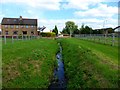
There are currently over 7.5m images from over14,400 individuals and you can help contribute to the project by visiting https://www.geograph.org.uk
Image Map
Images are licensed for reuse under creativecommons.org/licenses/by-sa/2.0
Notes
- Clicking on the map will re-center to the selected point.
- The higher the marker number, the further away the image location is from the centre of the postcode.
Image Listing (18 Images Found)
Images are licensed for reuse under creativecommons.org/licenses/by-sa/2.0
Image
Details
Distance
1
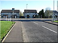
Houses on Burnside Place, Carronshore
Looking over a green.
Image: © JThomas
Taken: 25 May 2017
0.01 miles
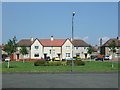
2
Street in Carronshore heading for minor junction
Image: © James Denham
Taken: 18 Apr 2009
0.04 miles
3
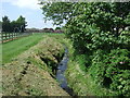
Chapel Burn, Carronshore
From the bridge on Burnside Place.
Image: © JThomas
Taken: 25 May 2017
0.06 miles
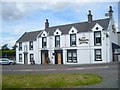
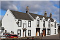
4
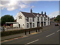
The Shore at Carronshore
Formerly the Blackmill Inn, refurbished by new owners in 2006
Image: © Tam and Karen
Taken: 16 Jul 2008
0.06 miles
5
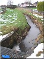
Chapel Burn
The burn is disappearing into a culvert running under Carronshore Road.
Image: © Richard Webb
Taken: 15 Jan 2010
0.07 miles
6
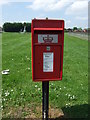
Elizabethan postbox on Burnside Place, Carronshore
Postbox No. FK2 25.
See Image] for context.
Image: © JThomas
Taken: 25 May 2017
0.07 miles
7
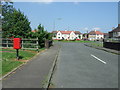
Burnside Place, Carronshore
Showing position of Postbox No. FK2 25.
See Image] for postbox.
Image: © JThomas
Taken: 25 May 2017
0.07 miles