IMAGES TAKEN NEAR TO
Dorrator Road, FALKIRK, FK2 7YL
Introduction
This page details the photographs taken nearby to Dorrator Road, FK2 7YL by members of the Geograph project.
The Geograph project started in 2005 with the aim of publishing, organising and preserving representative images for every square kilometre of Great Britain, Ireland and the Isle of Man.

There are currently over 7.5m images from over14,400 individuals and you can help contribute to the project by visiting https://www.geograph.org.uk
Image Map
Images are licensed for reuse under creativecommons.org/licenses/by-sa/2.0
Notes
- Clicking on the map will re-center to the selected point.
- The higher the marker number, the further away the image location is from the centre of the postcode.
Image Listing (7 Images Found)
Images are licensed for reuse under creativecommons.org/licenses/by-sa/2.0
Image
Details
Distance
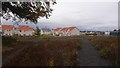
4
Beside the Carron
Land not in industrial use and probably destined for house building.
Image: © Richard Webb
Taken: 13 Sep 2017
0.10 miles
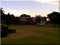
5
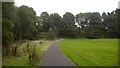
Path, Camelon
Edge of a large recreational area.
Image: © Richard Webb
Taken: 13 Sep 2017
0.15 miles
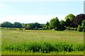
7
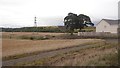
For now, edge of Falkirk
With house building taking place off camera to the right, I doubt there will be many more barley harvests here. There is a landfill site across the Carron.
Image: © Richard Webb
Taken: 13 Sep 2017
0.17 miles