IMAGES TAKEN NEAR TO
Millflats Street, FALKIRK, FK2 7PG
Introduction
This page details the photographs taken nearby to Millflats Street, FK2 7PG by members of the Geograph project.
The Geograph project started in 2005 with the aim of publishing, organising and preserving representative images for every square kilometre of Great Britain, Ireland and the Isle of Man.

There are currently over 7.5m images from over14,400 individuals and you can help contribute to the project by visiting https://www.geograph.org.uk
Image Map
Images are licensed for reuse under creativecommons.org/licenses/by-sa/2.0
Notes
- Clicking on the map will re-center to the selected point.
- The higher the marker number, the further away the image location is from the centre of the postcode.
Image Listing (12 Images Found)
Images are licensed for reuse under creativecommons.org/licenses/by-sa/2.0
Image
Details
Distance

9
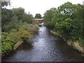
The River Carron at Carron
Taken from the old bridge. The bridge for the present main road can be seen beyond the trees
Image: © John Lord
Taken: 25 Sep 2008
0.19 miles
10
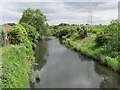
River Carron
Looking downstream on the tidal stretch of the river.
Image: © Richard Webb
Taken: 23 Jun 2010
0.20 miles