IMAGES TAKEN NEAR TO
Davids Loan, FALKIRK, FK2 7NS
Introduction
This page details the photographs taken nearby to Davids Loan, FK2 7NS by members of the Geograph project.
The Geograph project started in 2005 with the aim of publishing, organising and preserving representative images for every square kilometre of Great Britain, Ireland and the Isle of Man.

There are currently over 7.5m images from over14,400 individuals and you can help contribute to the project by visiting https://www.geograph.org.uk
Image Map
Images are licensed for reuse under creativecommons.org/licenses/by-sa/2.0
Notes
- Clicking on the map will re-center to the selected point.
- The higher the marker number, the further away the image location is from the centre of the postcode.
Image Listing (16 Images Found)
Images are licensed for reuse under creativecommons.org/licenses/by-sa/2.0
Image
Details
Distance
1
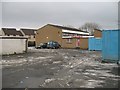
David's Loan
Houses beside David's Loan.
Image: © Richard Webb
Taken: 15 Jan 2010
0.01 miles
2
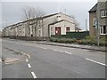
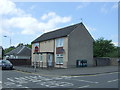
Bainsford Community Centre
With car park, off Davids Loan.
Image: © Richard Webb
Taken: 15 Jan 2010
0.03 miles
3
Carron Road
Looking across the junction with Davids Loan. Carron Road is a very busy route to and from Falkirk.
Image: © Richard Webb
Taken: 15 Jan 2010
0.05 miles
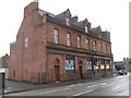
4
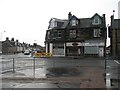
The Carronade Arms in Bainsford
97 Main Street.
Image: © JThomas
Taken: 25 May 2017
0.07 miles
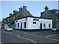
6
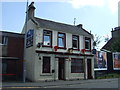
Sandstone buildings, Davids Loan
Substantial building on the junction of Davids Loan and Carron Road.
Image: © Richard Webb
Taken: 15 Jan 2010
0.10 miles
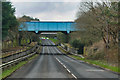
8
Hendry Street bridge over the A9
View north east from Main Street.
Image: © JThomas
Taken: 25 May 2017
0.14 miles
10
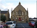
Bainsford Parish Church, Falkirk
Viewed from Smith Street to the south-west.
Image: © Peter Wood
Taken: 29 Sep 2017
0.18 miles