IMAGES TAKEN NEAR TO
KILLIN, FK21 8TY
Introduction
This page details the photographs taken nearby to FK21 8TY by members of the Geograph project.
The Geograph project started in 2005 with the aim of publishing, organising and preserving representative images for every square kilometre of Great Britain, Ireland and the Isle of Man.

There are currently over 7.5m images from over14,400 individuals and you can help contribute to the project by visiting https://www.geograph.org.uk
Image Map (Loading...)


Getting Data...Please wait
Leaflet Map data © OpenStreetMap
Images are licensed for reuse under creativecommons.org/licenses/by-sa/2.0
Notes
- Clicking on the map will re-center to the selected point.
- The higher the marker number, the further away the image location is from the centre of the postcode.
Image Listing (10 Images Found)
Images are licensed for reuse under creativecommons.org/licenses/by-sa/2.0
Image
Details
Distance
1
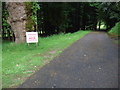
Edramucky
Pretty stark warning for potential visitors. I would have loved to have a look and chat to the locals about the history and geography in the area but I hadn't done my hair so didn't want to be caught on film.
Image: © Simon Johnston
Taken: 15 Jun 2009
0.11 miles
2
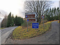
Junction of the minor road to Ben Lawers and Glen Lyon with the A827
Image: © Dr Richard Murray
Taken: 8 Feb 2008
0.15 miles
3
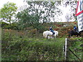
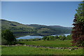
Horses above Milton Morenish
Just above Loch Tay, there is a good track for horse riding. At Milton Morenish there is an equestrian centre, so rides from here are good. It's also an excellent spot for sailing, canoeing & biking.
Image: © Alastair Seagroatt
Taken: 17 Oct 2005
0.16 miles
4
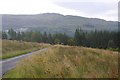
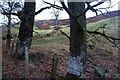
Felled area, Edramuchty
The horribly windthrown woodland at the foot of the Lairig an Lochain road has been felled.
Image: © Richard Webb
Taken: 4 Sep 2016
0.19 miles
7

Woodland, Edramuchty
Remaining trees after the conifers were clear felled.
Image: © Richard Webb
Taken: 4 Sep 2016
0.21 miles
8
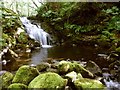
Falls on Allt a' Mhoirneas at Milton Morenish
Allt a' Mhoirneas (Morenish Burn) discharges into Loch Tay.
Image: © Simon Johnston
Taken: 14 Jun 2009
0.21 miles
9
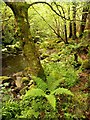
Woodland at Allt a' Mhoirneas
A natural bouquet of fern nestles beside a tree. The Morenish Burn runs over the falls http://www.geograph.org.uk/photo/1361373 at this point.
A closer look at that fern http://www.geograph.org.uk/photo/1361421
Image: © Simon Johnston
Taken: 14 Jun 2009
0.22 miles
10
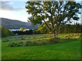
Frisbee golf at Loch Tay
This is a part of the frisbee golf course on the grounds of Loch Tay Highland Lodges. Loch Tay visible in the background.
Image: © Aleks Scholz
Taken: 21 Oct 2021
0.25 miles