IMAGES TAKEN NEAR TO
KILLIN, FK21 8TP
Introduction
This page details the photographs taken nearby to FK21 8TP by members of the Geograph project.
The Geograph project started in 2005 with the aim of publishing, organising and preserving representative images for every square kilometre of Great Britain, Ireland and the Isle of Man.

There are currently over 7.5m images from over14,400 individuals and you can help contribute to the project by visiting https://www.geograph.org.uk
Image Map
Images are licensed for reuse under creativecommons.org/licenses/by-sa/2.0
Notes
- Clicking on the map will re-center to the selected point.
- The higher the marker number, the further away the image location is from the centre of the postcode.
Image Listing (145 Images Found)
Images are licensed for reuse under creativecommons.org/licenses/by-sa/2.0
Image
Details
Distance
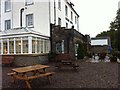
1
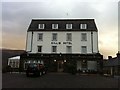
Killin Hotel
A well recommended hotel at the eastern end of the village.
Image: © Dave Fergusson
Taken: 24 Dec 2012
0.01 miles
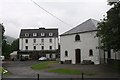
2
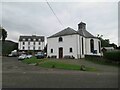
Killin and Ardeonaig Parish Church and Killin Hotel
Image: © Les Hull
Taken: 16 Sep 2020
0.01 miles
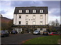
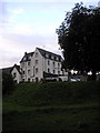
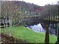
5
Killin Hotel
The Killin Hotel stands on the banks of the River Lochay, occupying the site of the old "Streethouse Inn", a 17th Century refreshment stop for the Aberfeldy to Tyndrum coach.
Image: © Andrew Wood
Taken: 4 Aug 2011
0.02 miles
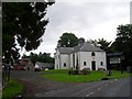
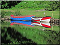
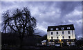
10
A swollen River Lochay
The Killin Hotel pier has been submerged.
Image: © Dave Fergusson
Taken: 24 Dec 2012
0.02 miles